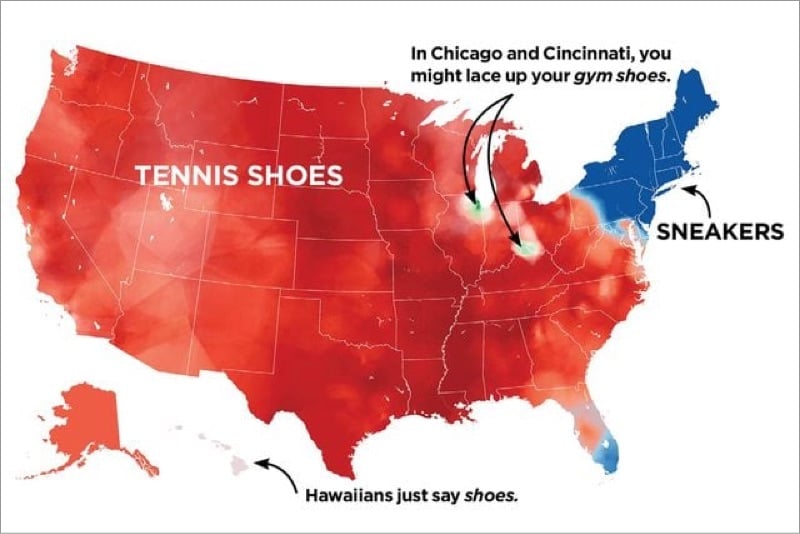
Growing up in northern Wisconsin, we said “tennis shoes” or “tennies” most of the time (even though very little actual tennis was being played) and “gym shoes” less often. I hadn’t really heard of “sneakers” as a kid and never used it. (Shoes for sneaking? Huh?) My kids were born in NYC and they give me shit every time I tell them to put their tennies on. 🤷♂️
What do you call athletic shoes? Tennies? Sneakers? Kicks? Trainers? Gym shoes? Some other weird thing? (via @dens)
Back in December 2020, Nepal and China announced that the height of Mount Everest had been remeasured and updated from a height of 8,848 meters (29,028.87 feet) to 8,848.86 meters (29,031.7 feet). Did the mountain get taller? Or the measuring more precise? And how do you measure the height of a mountain — or “sea level” for that matter — anyway?
In December of 2020, China and Nepal made a joint announcement about a new measurement for Mount Everest: 8,849 meters. This is just the latest of several different surveys of Everest since the first measurement was taken in 1855. The reasons why the height has fluctuated have to do with surveying methodology, challenges in determining sea level, and the people who have historically been able to measure Everest.
Also worth noting the (romanised) Nepalese and Tibetan names for the mountain: Sagarmāthā and Chomolungma. The section on its name at Wikipedia is pretty interesting — apparently George Everest, for whom the mountain was named, pronounced his name differently than we all do today.
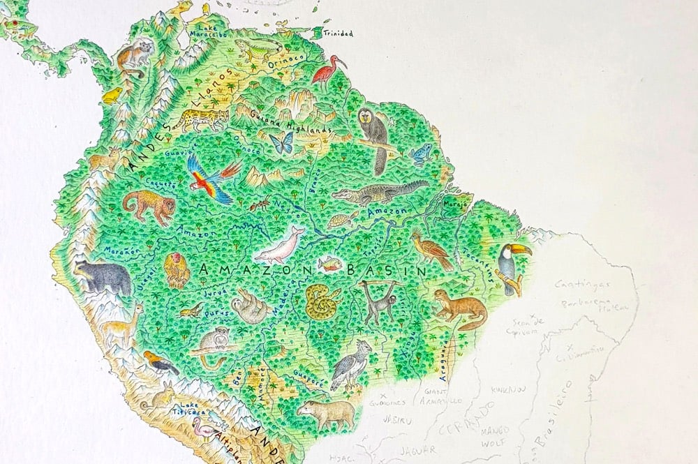
Commenced in mid-2020, this is a brand new map of the world. Rather than the endless skylines and cultural features of North America: Portrait of a Continent, I wanted the wild character of Earth to shine.
While you won’t find cities or borders on this map, you will find geographic labels. This is important. From mountain ranges to deserts, rivers to rainforests, the labels here offer a detailed, accurate outline of Earth’s natural geography.
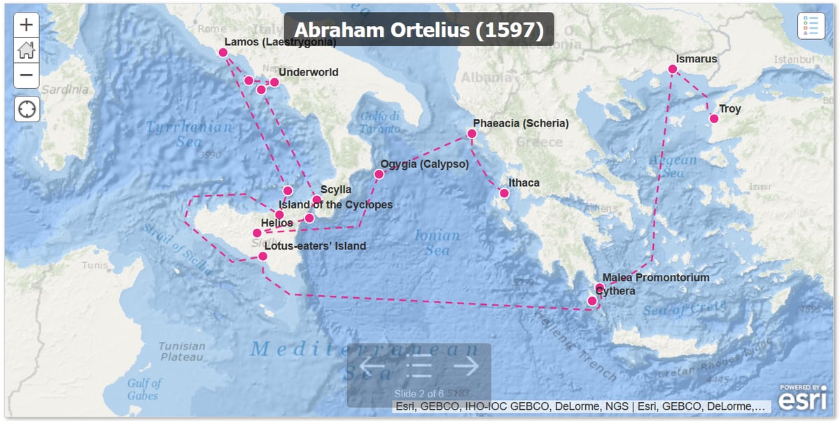
We’ve looked before at maps of Odysseus’s travels in The Odyssey (as Jason wrote in 2018, “that dude was LOST”). But it turns out — and maybe this shouldn’t be surprising — that it’s not easy to figure out exactly where Odysseus was in the Mediterranean Sea for all that time.
Ithaca is one of a group of four islands, with smaller islands nearby, but it faces west while the others face east. (What does it mean for an island to face a direction?) It has forests and at least one mountain, and it is a good place for raising children. That isn’t much to go on.
Then there’s the whole question of what we gain from mapping The Odyssey in detail anyways. Some of it is plugging a gap in our imagination; we’ve gotten used to fantasy worlds supplying us with maps, and The Odyssey is a fantasy world that coexists with our own. But the level of detail is obsessive.
Attempts to map the Odyssey seem different from other attempts to locate the sites of famous myths and legends. Atlantis was the site of a wondrous civilization, Troy the landscape for an epic battle; finding them in the real world would mean discovering rich sources of evidence about past cultures. El Dorado’s location seems to have been coveted mainly for the lost city’s purported riches, Bimini for its rumored fountain of youth. But what do we gain by knowing where Helios kept his cows? Or which rocky, uninhabitable cave a kidnapping nymph called home?
Nevertheless, there’s a long history of scholars, artists, kings, and more attempting to write themselves into the myth of The Odyssey. The Aeneid, which simultaneously reimagines the founding of Rome as part of the story of the Iliad and Odyssey and elevates Virgil’s Latin poetry to the epic heights of Homer, is the most famous attempt to shore up a claim to legitimacy by appealing to the reality of the Odyssey’s ancient past.
But where exactly was Odysseus? Was he mostly in the Aegean and Italy, as Abraham Ortelius believed in 1597? Or was he scattered into the western Mediterranean, Spain, Corsica, North Africa, as Peter Struck thinks? We’ll probably never know. That dude was LOST.
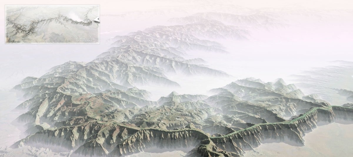
Some of my earliest memories of the place had to do with the trippy feeling of my eyes and mind trying to make sense of the scale. I had seen many mountain ranges and vistas, including some on the way, but the vast negative space played havoc with my perception of magnitude. I’ve felt it a few times since, but never like that first Grand Canyon overlook.
I wondered, then, if flipping the Grand Canyon into a Grand Mountain might in some way help me make sense of its scale. I’m much more accustomed to seeing the mass of something rather than the massive void of something. So, here’s what that looks like.
For reference, the depth at the deepest part of the canyon is ~6000 feet and the top of the canyon is between 6000 and 8000 feet above sea level, so the highest point of the Grand Mountains would be somewhere between 12,000 and 14,000 feet, in the ballpark of the Rocky Mountains. It would be fun to see what an inverted Kola Superdeep Borehole would look like: a 9-inch spire rising 40,000 feet into the air from a starting point very close to sea level, more that 10,000 feet higher than Everest.
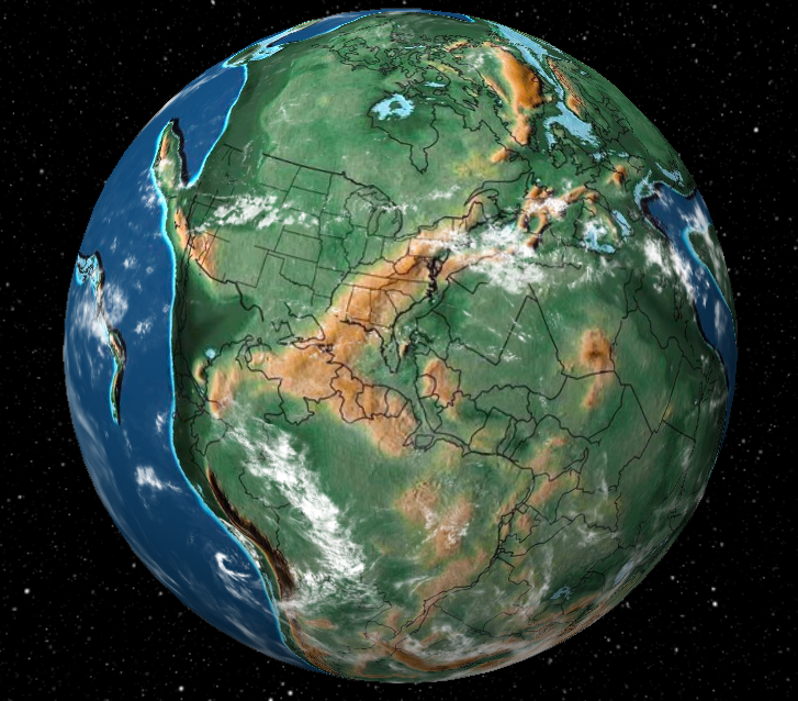
This is fun to play with: Dinosaur Pictures has a Google Earth-style globe that shows the state of the planet at various intervals 20 million, 200 million, or 750 million years ago, with plenty of stops in between. You can watch India collide into the rest of Asia, or jump to the birth (and death) of dinosaurs, the first flowers, the first hominids, etc. And you can watch the whole planet or zero in on an individual contemporary address.
One point of view that I found oddly soothing: the middle of the Pacific Ocean. All over the planet, millions of years are passing by, transforming the land-bound flora and fauna through tectonic and climatic upheavals, and the ocean just… stays the ocean. Big things are happening below the surface, but the biggest part of the planet just continues to be this deep blue, undisturbed marble.
Americans generally have a skewed view of their country’s place in the world, both metaphorically and geographically speaking. For instance, the US state closest to Africa is… Maine? And Minneapolis is as far north as Venice, Italy.
They didn’t cover my favorite US geographical oddity though: what’s the northernmost state in the contiguous 48 states? Unless you know it by rote, the answer will probably be surprising to you.
A couple of years ago, Wayne Easton witnessed the Mahlongwa River cutting a new channel into the Indian Ocean. As the video above begins, you can see water from the river just starting to trickle down the sand into the sea. Sand being sandy, the process happens pretty quickly. As you can see in this second video, the trickle becomes a rushing torrent in a matter of just minutes.
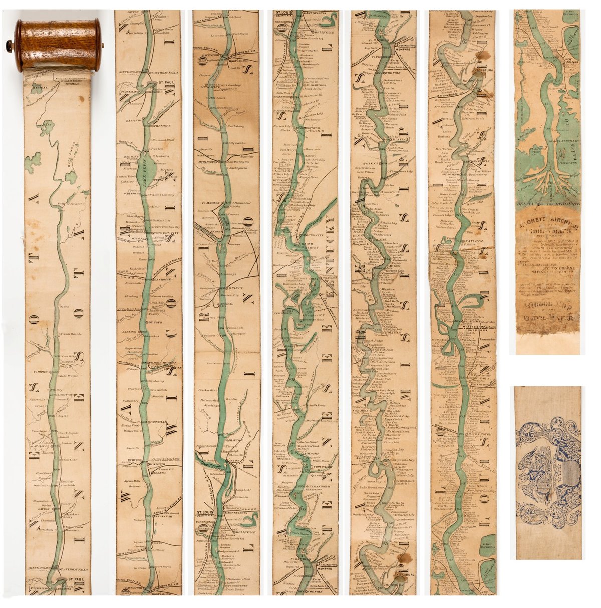
The Mississippi River runs for more than 2300 miles straight through the heartland of America, more or less straight from north to south. Representing the river in any detail presented a challenge for mapmakers wishing to provide maps to those wanting to travel along the river. In 1866, Coloney & Fairchild solved the problem by producing the Ribbon Map of the Father of Waters, a 2-inch wide & 11-foot long map that spooled up into a carrying case via a hand crank. From Nenette Luarca-Shoaf’s description of the map:
Coloney and Fairchild’s patented apparatus required that the single sheet be cut into strips, attached end-to-end, mounted on linen, and then rolled inside a wooden, metal, or paper spool (fig. 4). The resulting portability of the map was crucial because, as advertisements indicated, it was intended for business travelers, steamboat navigators, and tourists.
Per Betteridge’s law of headlines and also the map above, my answer is clearly no. You can try it yourself here…you draw them one at a time and it adds them to the map automagically. I’m going to blame my trackpad use a little, but I’m not sure I would have done much better had I drawn with a pencil and looked a map beforehand.
Update: Your periodic reminder that Senator Al Franken can draw all 50 US states from memory with astonishing accuracy.
Among the requirements that all immigrants must meet to become a naturalized US citizen is a civics test covering US history and government. The test contains 100 questions, 10 of which are verbally posed by a Citizenship and Immigration Services officer…no multiple choice. Applicants must answer 6 out of 10 correctly to pass. The questions include:
What is the supreme law of the land?
What is freedom of religion?
What stops one branch of government from becoming too powerful?
The House of Representatives has how many voting members?
What is the name of the President of the United States now?
Under our Constitution, some powers belong to the states. What is one power of the states?
What are two ways that Americans can participate in their democracy?
The Federalist Papers supported the passage of the U.S. Constitution. Name one of the writers.
When must all men register for the Selective Service?
Name one war fought by the United States in the 1800s.
What was one important thing that Abraham Lincoln did?
Why does the flag have 13 stripes?
Before he was President, Eisenhower was a general. What war was he in?
Name one of the two longest rivers in the United States.
Name two national U.S. holidays.
Then there is Question 12: What is the “rule of law”?
I showed it to lawyers and law professors. They were stumped.
There are four acceptable answers: “Everyone must follow the law”; “Leaders must obey the law”; “Government must obey the law”; “No one is above the law.”
Judge Richard Posner, the constitutional scholar who serves on the U.S. Court of Appeals in Chicago, was unhappy. “These are all incorrect,” he wrote me. “The rule of law means that judges decide cases ‘without respect of persons,’ that is, without considering the social status, attractiveness, etc. of the parties or their lawyers.”
Examiner: “Alright, here’s your last question: What was the cause of the Civil War?”
Apu: “Actually there were numerous causes. Aside from the obvious schism between the abolitionists and the anti-abolitionists, economic factors both domestic and international…”
Examiner: “Hey, hey…”
Apu: “Yep?”
Examiner: “Just… just say ‘slavery’”.
Apu: “Slavery it is, sir.”
This would never happen in a million years, but I would love for someone to sit down with Donald Trump to see how many of these he could answer. Like I said, if you haven’t studied, some of the questions are not that easy. But surely the President of the United States should be able to get almost all of them correct…
I was always good at tests in school because I learned early on the difference between the correct answer and the answer you’re supposed to give. Most of the time, they’re the same but not always.↩
The question from the actual test reads “Name one problem that led to the Civil War” and the three suggested answers are “slavery”, “economic reasons”, and “states’ rights”.↩
It makes sense that villages and towns would develop a short distance away from each other so that people living nearby wouldn’t have to travel far to sell their goods, bank, or go to school. But what about cities? Geography has a lot ot do with where cities are located.
If you enjoy this video but haven’t read Jared Diamond’s Guns, Germs, and Steel yet, you probably should.
This interactive experience enabled people to explore these changes like never before — to watch the sprouting of Dubai’s artificial Palm Islands, the retreat of Alaska’s Columbia Glacier, and the impressive urban expansion of Las Vegas, Nevada. Today, we’re making our largest update to Timelapse yet, with four additional years of imagery, petabytes of new data, and a sharper view of the Earth from 1984 to 2016.
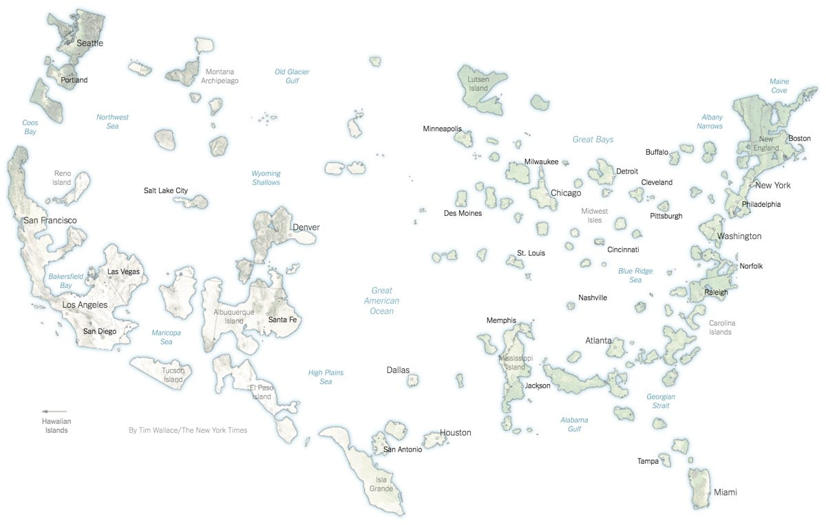
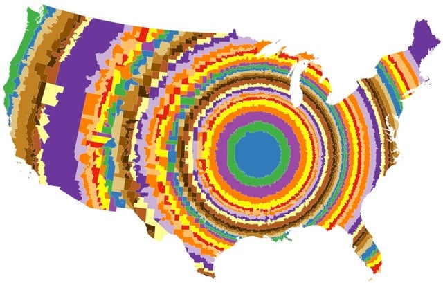
The New York Times took a map of the US and split it in two based on areas that voted for Clinton and Trump in the 2016 election. (Clinton’s map is pictured above.)
Mrs. Clinton’s island nation has large atolls and small island chains with liberal cores, like college towns, Native American reservations and areas with black and Hispanic majorities. While the land area is small, the residents here voted for Mrs. Clinton in large enough numbers to make her the winner of the overall popular vote.
That’s fun, but it’s another reminder of how strictly geographical maps distort election results.
P.S. They missed a real opportunity to call the chain of islands in the southern states The Cretaceous Atoll.
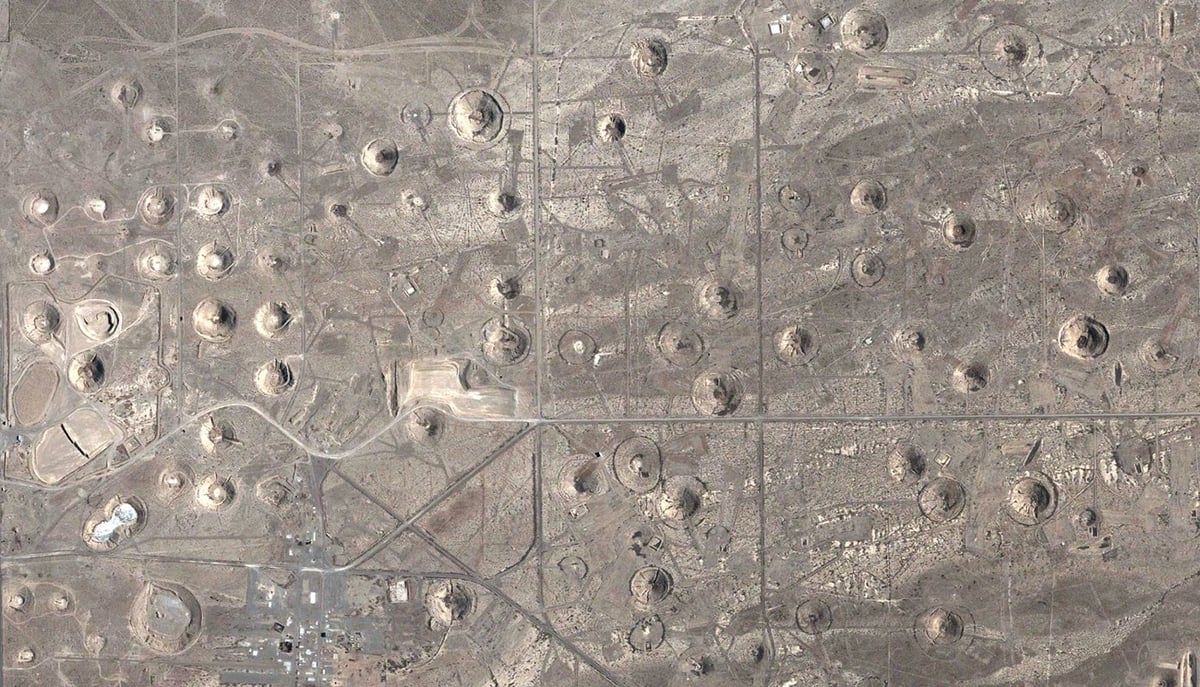
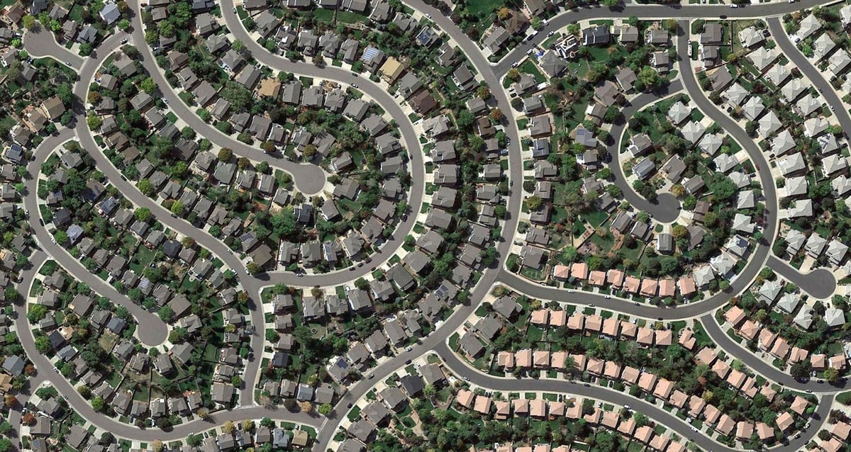
Humans have lived in what we now call the American Southwest for centuries, making a wide impact on the land, much of it visible from aerial and satellite photography. Nuclear detonations, housing subdivisions, oil exploration, hydroelectric facilities, solar power facilities, roads, mines, farms, ranches, cities, and towns have altered much of the land over the years.
The photos, from top to bottom: a road cuts through White Sands, NM, a former nuclear testing site in NV (those are craters left from nuclear explosions), and a housing development south of Denver.
In his film Best of Luck With the Wall, director Josh Begley takes us on a journey across the entire US/Mexico border. It’s a simple premise — a continuous display of 200,000 satellite images of the border from the Pacific Ocean to the Gulf of Mexico — but one that delivers a powerful feeling of how large the world is and how meaningless borders are from a certain perspective.
The project started from a really simple place. It was about looking. It was about the pure desire to understand the visual landscape that we are talking about when we are talking about the southern border of the United States. What does the southern border of the United States actually look like? And in that sense it was a very simple gesture to try to see the border in aggregate. If you were to compile all 2000 miles and try to see it in a short space — what would that look like? In another sense it grew out of the discourses as you suggested. The way migration is talked about in our contemporary moment and in particular the way migration is talked about in terms of the southern border of the U.S. So part of this piece is a response to the way migrants and borders are talked about in our politics. And it’s also just a way of looking at landscape as a way to think about some of those things.
The online version of the film is 6 minutes long, but Begley states that longer versions might make their way into galleries and such.
See also the map accompanying Parag Khanna’s recent piece, A New Map for America, which calls for the creation of seven mega-regions centered around metropolitan clusters in place of the lower 48 states: the Pacific Coast, the Inland West, the Great Plains, the Gulf Coast, the Great Lakes, the Southeast Manufacturing Belt, and the Great Northeast.
These days, in the thick of the American presidential primaries, it’s easy to see how the 50 states continue to drive the political system. But increasingly, that’s all they drive — socially and economically, America is reorganizing itself around regional infrastructure lines and metropolitan clusters that ignore state and even national borders. The problem is, the political system hasn’t caught up.
America faces a two-part problem. It’s no secret that the country has fallen behind on infrastructure spending. But it’s not just a matter of how much is spent on catching up, but how and where it is spent. Advanced economies in Western Europe and Asia are reorienting themselves around robust urban clusters of advanced industry. Unfortunately, American policy making remains wedded to an antiquated political structure of 50 distinct states.
To an extent, America is already headed toward a metropolis-first arrangement. The states aren’t about to go away, but economically and socially, the country is drifting toward looser metropolitan and regional formations, anchored by the great cities and urban archipelagos that already lead global economic circuits.
Holy shit, could you imagine? Most of America would have a fit over this.
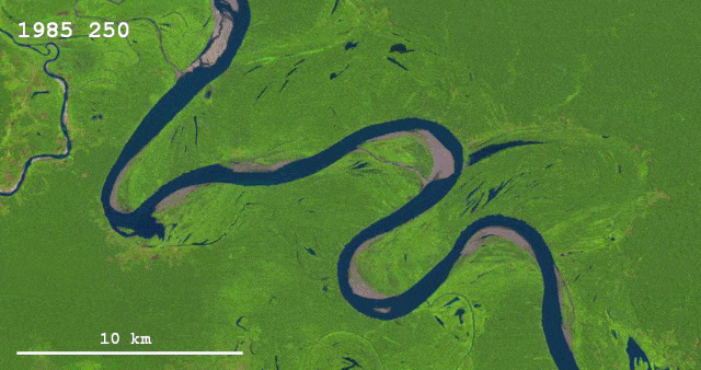
Rivers change course as they flow through the years. This is an animation of the fast-changing Ucayali River in Peru built from satellite imagery over the past 30 years.
Beyond the Sea is a neat project by Andy Woodruff that visualizes what lies across the ocean from the world’s coastlines. For instance, standing on the coast in North America looking straight out, you might see Brazil or the west coast of Africa, but also the east coast of Africa, India, and even Iran.
In the northern reaches of Newfoundland, near the town of St. Anthony, is the Fox Point Lighthouse. I’ve never been there, but I know it has one of the most impressive ocean views in the world. If you face perpendicular to the right bit of rocky coastline there and gaze straight across the ocean, your mind’s eye peering well beyond the horizon, you can see all the way to Australia.
What’s really across the ocean from you when you look straight out? It’s not always the place you think.
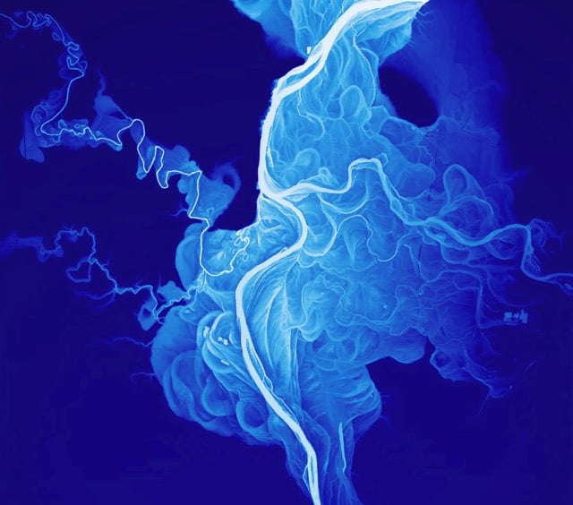
If you measure the contours of a river valley with Lidar (like radar with lasers), you get a beautiful map of all the historical river channels. The image above was taken from a poster of the historical channels of the Willamette River…click through to see the whole thing. See also Harold Fisk’s meander maps of the Mississippi River.
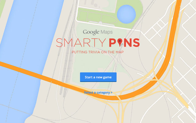
Smarty Pins is a Google Maps-based geography quiz…you drop pins on the map to answer questions. You start with a total of 1000 miles and the game subtracts the number of miles you’re off by for each answer.
I just spent far too long playing this. Can you beat my score of 39? Also, this reminds me of GeoGuessr, which is a lot more difficult.
People in the Koana Islands love baseball. The first league play started in 1882, barely six years after the MLB. Between the top-tier, Triple- and Double-A leagues, there are over 180 teams spanning the island nation. Fans are so rabid that there’s even talk of expanding to a Single-A league, adding even more teams. If you’re a baseball fan, you might be surprised you’ve never heard of this. You’ll be even more surprised when you try to find the Koana Islands. That’s because the 32-island chain, with its nine major cities, 11 national parks, 93 million residents and a landmass that is equal to Spain and Sweden combined does not really exist.
Alan Taylor recently investigated where Google Maps’ Street View coverage ends — “whether blocked by geographic features, international borders, or simply the lack of any further road” — and compiled a photographic look at the ends of the road.
This is like CSI for geography dorks: you’re plopped into a random location on Google Street View and you have to guess where in the world you are. So much fun…you get to say “wait, zoom in, enhance, whoa, back up” to yourself while playing. My top score is 14103…what’d you get? p.s. Using Google in another tab is cheating! (thx, nick)
A list of the northernmost, southernmost, easternmost and westernmost cities/towns/villages in all 50 US states.
Vermont — Northernmost: Derby Line. Southernmost: Vernon (specifically South Vernon area). Easternmost: Beecher Falls. Westernmost: Chimney Point.
California — Northernmost: Tulelake (note: Fairport is more northerly but is considered a “former settlement”) Southernmost: San Diego (San Ysidro District). Easternmost: Parker Dam. Westernmost: Ferndale.
New York — Northernmost: Rouses Point. Southernmost: Staten Island-New York City (Tottenville Neighborhood) Easternmost: Montauk. Westernmost: Findley Lake.
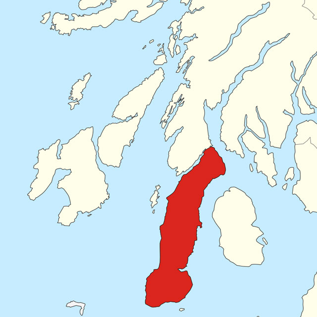
The British Board of Film Classification was said to have an informal rule called the Mull of Kintyre test about the erectness of penises shown in films and videos. If a man’s penis was at an angle greater than Scotland’s Kintyre peninsula, you couldn’t show it.
The BBFC would not permit the general release of a film or video if it depicted a phallus erect to the point that the angle it made from the vertical (the “angle of the dangle”, as it was often known) was larger than that of the Mull of Kintyre, Argyll and Bute, on maps of Scotland.
The BBFC has denied the test was ever applied. Sometimes a Scottish peninsula is just a Scottish peninsula. (via @josueblanco)
Dr. Maria Seton, our cheif scientist, noticed that on the path that we were taking there was this very unusal island. Essentially it was on all the Google Earth maps and it was on all the weather charts. But when you zoom in on it it was just a black blob. Google had no photos from it. It was just this sort of slit in the Earth.
My average error was 8 miles. A better test would be to start each state with the blank map…placing Colorado in the western part of the country without any guide is much tougher than doing it last. (via @notrobwalker)

Stay Connected