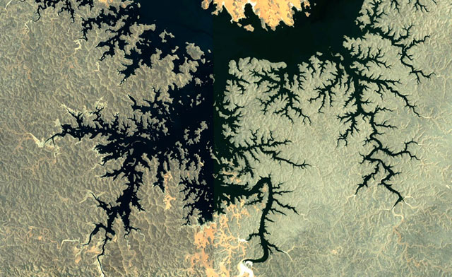
kottke.org

...is a weblog about the liberal arts 2.0 edited by Jason Kottke since March 1998 (archives). You can read about me and kottke.org here. If you've got questions, concerns, or interesting links, send them along.

14 kottke.org posts about Google Earth


Mapping North Korea

North Korea is in the news. Not much is known about the secretive country, but a group of interested citizens has been mapping North Korea on Google Earth using snippets of news reports here and there.

More than 35,000 people have downloaded Mr. Melvin's file, North Korea Uncovered. It has grown to include thousands of tags in categories such as "nuclear issues" (alleged reactors, missile storage), dams (more than 1,200 countrywide) and restaurants (47). Its Wikipedia approach to spying shows how Soviet-style secrecy is facing a new challenge from the Internet's power to unite a disparate community of busybodies.

"Here is one of the most closed countries in the world and yet, through this effort on the Internet by a bunch of strangers, the country's visible secrets are being published," says Martyn Williams, a Tokyo-based technology journalist who recently sent Mr. Melvin the locations of about 30 North Korean lighthouses.

Update: The map itself is available here. (thx, brian)

That's no moon, it's a seamount

There's a fascinating tidbit in this Google blog post about the non-discovery of Atlantis in Google Earth. It concerns how the depth of the ocean floor is measured.

Now you're probably wondering where the rest of the depth data comes from if there are such big gaps from echosounding. We do our best to predict what the sea floor looks like based on what we can measure much more easily: the water surface. Above large underwater mountains (seamounts), the surface of the ocean is actually higher than in surrounding areas. These seamounts actually increase gravity in the area, which attracts more water and causes sea level to be slightly higher. The changes in water height are measurable using radar on satellites.

Wow! (via ben fry)

By Jason Kottke    Mar 5, 2009    Google Earth   gravity   maps

Like the Silver Surfer

Surfing Google Earth using a Wii Fit Balance Board. (via quantified self)

By Jason Kottke    Feb 17, 2009    Google Earth   maps   remix   video   Wii   wiifit

Google Earth on iPhone

Wow, Google Earth is now available for the iPhone. The early reviews at the iTunes Store are mixed; looks like it's crashing a lot. (via df)

By Jason Kottke    Oct 27, 2008    Google Earth   iPhone   maps

From Google Earth to a gold medal

Kristin Armstrong, the Olympic gold medalist in the women's individual time trial in road cycling, took a GPS unit along with her when she previewed the road course in Beijing in December 2007. When she got home to Idaho, she d/led the data, put it into Google Earth, and found a similar local loop on which to train.

This capability along with having the elevation profile proved invaluable in my preparation for my Gold Medal race.

(via matt's a.whole)

The newest version of Google Earth includes 3

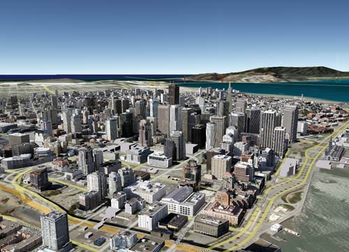
The newest version of Google Earth includes 3-D photorealistic buildings, sunlight (with shadows on those realistic 3-D buildings), and a Spiderman-esque swooping action. Here's a "photo" I snapped of downtown San Francisco.

Downtown San Francisco on Google Earth

You can just see the 3-D photorealistic Golden Gate Bridge peeking up in the background. See some more examples at Google's LatLong blog.

Google Earth now displays location-specific news from

Google Earth now displays location-specific news from the NY Times.

I read a lot of news by surfing the Internet, as do many of my colleagues and friends, and I've always dreamed of a way to browse news based on geography. What's happening in Paris today? What are the top headlines in Japan?

God's Eye View presents four important Biblical

God's Eye View presents four important Biblical events as if captured by Google Earth, including The Crucifixion, Noah's Ark, and Moses parting the Red Sea.

By Jason Kottke    Dec 17, 2007    art   Google   Google Earth   religion

Historical maps on Google Earth

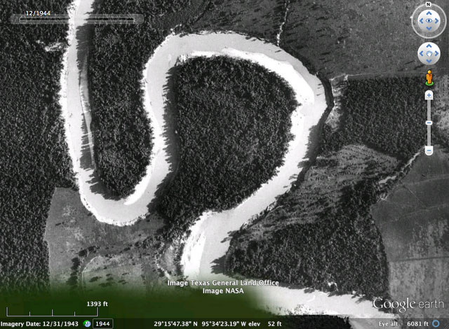
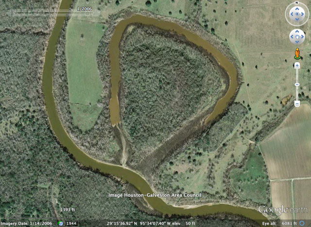
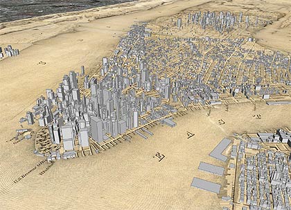
Google Earth recently added some maps from the David Rumsey Historical Map Collection to their software, so you can just click them on and off on the globe. Included are a US map from 1833, a 1680 map of Tokyo, Paris from 1716, and a world map from 1790. I spent some time exploring the map of New York from 1836. Here's a screenshot of the southern tip of Manhattan with the present-day buildings turned on:

Nyc Gearth Rumsey

A larger version is available on Flickr. Google Earth continues to be a fantastic software product. It's almost more of a game than an atlas or educational program...so much fun.

Related: I did a project using Google Earth called Manhattan Elsewhere and made a scrollable, zoomable version of Viele's Map of Manhattan.

By Jason Kottke    Nov 13, 2006    davidrumsey   Google   Google Earth   maps   NYC

Some Tour de France fans have mapped

Some Tour de France fans have mapped the entire route of the 2006 Tour in Google Earth. (via airbag)

3-D NYC buildings from Google Earth (extracted

3-D NYC buildings from Google Earth (extracted with OGLE) printed out on a 3-D printer.

By Jason Kottke    May 12, 2006    3-D   Google   Google Earth   maps   NYC   ogle   remix

Neat "center of gravity" calculator for Google

Neat "center of gravity" calculator for Google Earth. Inspired by Cory's map of the center of gravity of Manhattan's Starbucks.

Eyebeam's Mike Frumin has released OGLE (OpenGL

Eyebeam's Mike Frumin has released OGLE (OpenGL Extrator), a software package for extracting 3-D data from Windows applications. This means you can do stuff like grab the 3-D likeness of your World of Warcraft character and print it out on a 3-D printer or insert him into a Manhattan landscape (grabbed from Google Earth). Announcement here.

A first look at Google Earth, the

A first look at Google Earth, the replacement for the Keyhole mapping software. "View Railroads, Subway lines and Bus routes along with all their stops. Or select multiple locations and have Google give you directions."

By Jason Kottke    May 31, 2005    Google   Google Earth   maps

kottke.org, quickly...

The best way to get a sense of what kottke.org is all about is to head to the front page or check out some random entries from the archives.

Tags related to Google Earth:

maps (234)    Google (193)    ogle (2)    3-D (10)    NYC (694)    sports (486)    remix (207)    cycling (19)

Looking for work?

See more on the Job Board.

Tags, tags, tags

Many posts on kottke.org have been "tagged" with keywords, which activity results in collections of related posts like sports, infoviz, or best of.

Recently popular tags (last 3 weeks)

The 2000s (14)    post updates (43)    video (746)    USA (13)    movies (1072)    books (737)    science (634)    lists (646)    food (666)    photography (821)    art (389)    best of (372)    sports (486)    advertising (178)    maps (234)

All-time popular tags

movies (1072)    photography (821)    video (746)    books (737)    NYC (694)    food (666)    lists (646)    science (634)    design (612)    sports (486)    music (405)    art (389)    business (382)    best of (372)    TV (370)

Useful favorites

photography (821)    economics (202)    lists (646)    best of (372)    infoviz (163)    food (666)    NYC (694)    firstworldproblems (4)    cities (135)    restaurants (188)    video (746)    timelapse (3)    interviews (256)    language (272)    maps (234)    fashion (164)    NSFW (63)    remix (207)

Random tags

taxes (6)    anncoulter (2)    best of 2006 (25)    hoax (3)    nicholascage (2)    rosecransbaldwin (3)    presentations (3)    mattgroening (3)    dancing (13)    weblogs (357)    giselebundchen (2)    djspooky (3)    flags (4)    cycling (19)    Safari (6)