kottke.org posts about Google Maps
Artur Grabowski spent much of 2017 comparing three mapping apps (Google Maps, Apple Maps, Waze) to see which one was the most accurate and resulted in the fastest route times. After 120 trips, the data showed that Google Maps got him to his destinations most quickly, Apple Maps made the most accurate predictions, and Waze promised the fastest times but often under-delivered.
So that’s some News You Can Use™ (assuming the results are statistically significant), but then Grabowski goes on to discuss why each app might over- or under-promise on route times based on the presence of advertising:
For Apple, Maps is a basic solution for its average user who wants a maps solution out of the box. Apple Maps does not directly drive ad or subscription revenue for Apple so there is less reason for Apple to incentivize iOS users to use Apple Maps over other solutions. However, Apple does care about user experience, and sandbagging trip time estimates so that users arrive at their destination on time results in a great user experience. Hence, I believe that Apple is intentionally conservative with estimated arrival times.
At the other extreme, Waze (Alphabet) makes money through ads when you use their app. What better way to get people to use your navigation app than by over-promising short trip times when no one takes the time to record data and realize that you under-deliver? If an unsuspecting user opens Apple Maps and sees a 34-minute route and compares that to 30-minutes in Waze, the deed is done. Now Waze has a life-long customer who doesn’t realize they’ve been hoodwinked and Waze can throw at them stupidly annoying ads.
If that’s happening with your mapping app, just think of how your search results, Facebook newsfeed, and Instagram feed are manipulated to be more amenable to advertising. Oh, and don’t forget about almost everything you watch and read. Even Black Panther and Get Out had paid product placements. I wonder how many more car chases there are in action movies due to deep pockets at Acura or Mercedes or BMW. (via df)
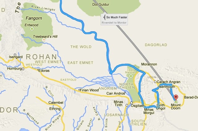
Frodo (and Sam) made their way from Hobbiton to Mordor in six months and now you can see the route they took on Google Maps. “This route has trolls.” LOL. Full size image here. (via bb)
Update: From 2002, Mapquest directions for walking from Hobbiton to Mt Doom. (thx, seth)
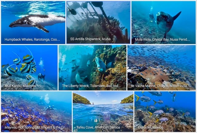
Google Street View includes views from under the Earth’s oceans. You can tour shipwrecks, swim with humpback whales, and virtually dive down to dozens of coral reefs.
P.S. You can also climb Yosemite’s El Capitan on Google Street View, which is SO OMG TERRFIYING THAT I CANT BE BOTHERED TO CORRECTM Y TPYING. Are anyone else’s palms soaking wet right now? (via mr)
Ok, April Fools’ is still idiotic, but this is pretty cool: you can play Pac-Man in any neighborhood on Google Maps.
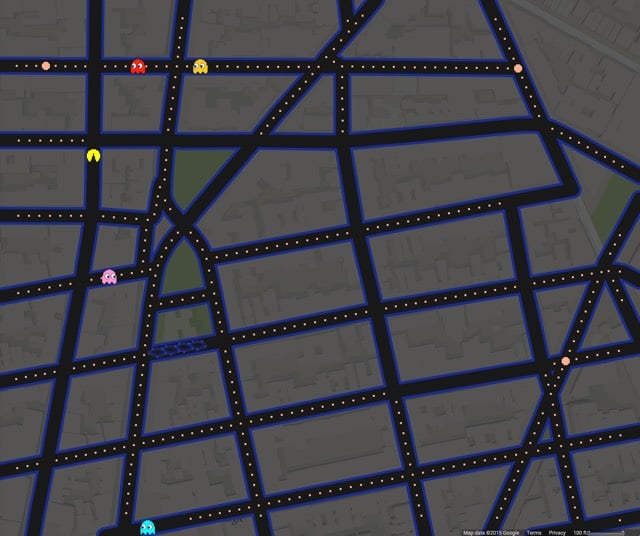
NYC’s West Village is a fun place to play. See also Pac-Manhattan, a real-life game of Pac-Man played on the streets of Manhattan in 2004 by a group of ITP students, including Foursquare CEO Dennis Crowley.
Smarty Pins is a Google Maps-based geography quiz…you drop pins on the map to answer questions. You start with a total of 1000 miles and the game subtracts the number of miles you’re off by for each answer.
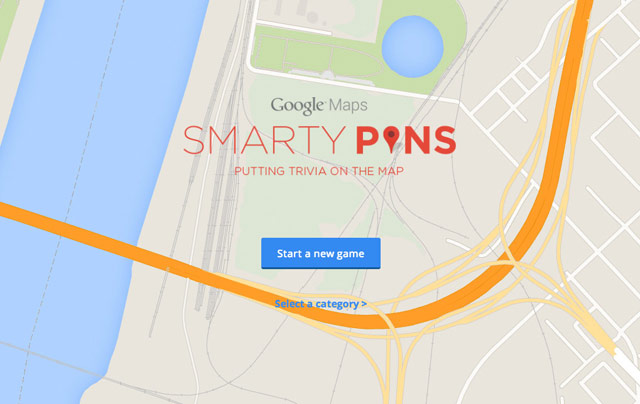
I just spent far too long playing this. Can you beat my score of 39? Also, this reminds me of GeoGuessr, which is a lot more difficult.
If you look at the Washington Monument in Google Maps, the monument’s shadow follows the motion of the Sun throughout the day.
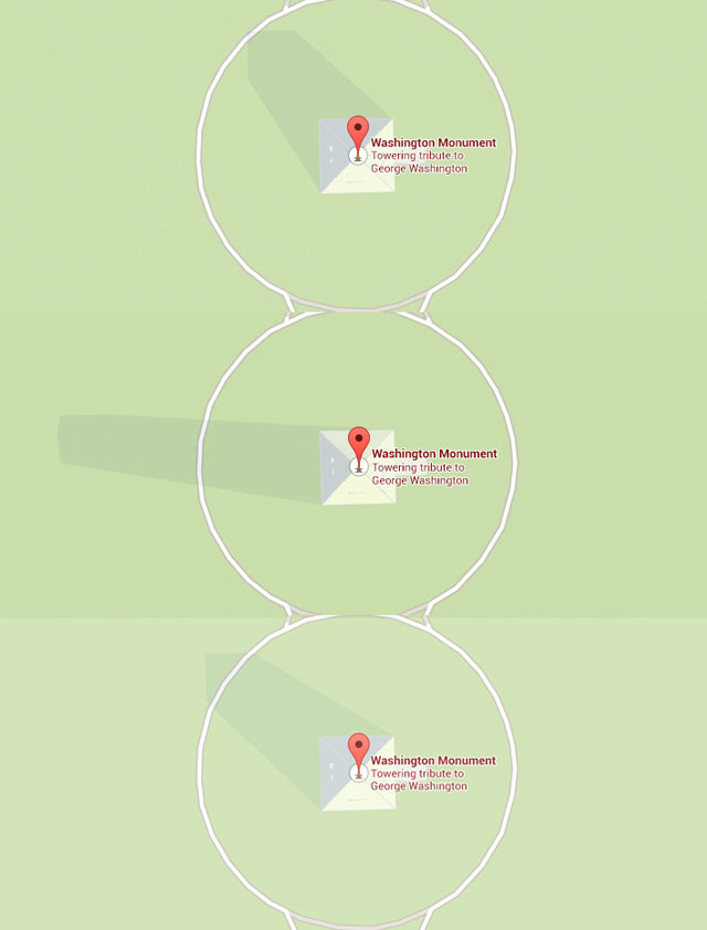
The utility of this feature is unclear, but that is some impressive attention to detail. (via @sippey, @kennethn, @chrisfahey)
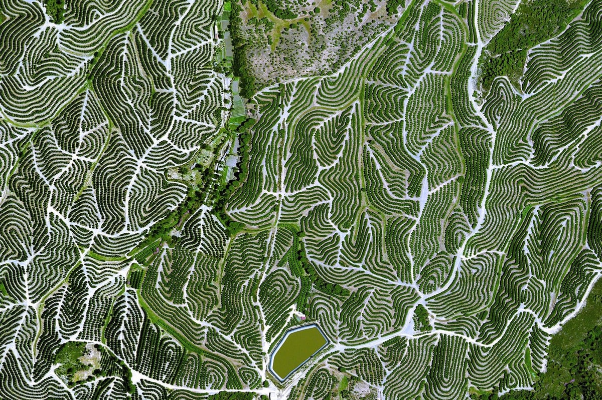
The Daily Overview offers up an interesting satellite photo every day. The site’s name is inspired by the Overview Effect:
The Overview Effect, first described by author Frank White in 1987, is an experience that transforms astronauts’ perspective of Earth and mankind’s place upon it. Common features of the experience are a feeling of awe for the planet, a profound understanding of the interconnection of all life, and a renewed sense of responsibility for taking care of the environment. ‘Overview’ is a short film that explores this phenomenon through interviews with five astronauts who have experienced the Overview Effect. The film also features important commentary on the wider implications of this new understanding for both our society, and our relationship to the environment.
The Planetary Collective made a short documentary about the Overview Effect:
(thx, pavel)
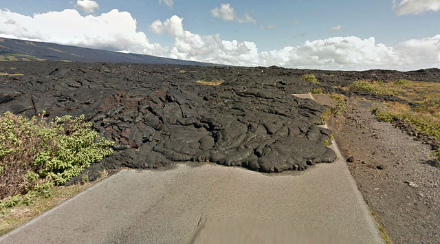
Alan Taylor recently investigated where Google Maps’ Street View coverage ends — “whether blocked by geographic features, international borders, or simply the lack of any further road” — and compiled a photographic look at the ends of the road.
(via @faketv)
Working with the USGS, NASA, and Time, Google has built a viewer for satellite image time lapses. Among the images are those of the deforestation of the Amazon rainforest, the retreat of an Alaskan glacier, and the growth of Dubai. You can also refocus the map on any other area you want. More info here and here’s the extensive Time feature.
This is like CSI for geography dorks: you’re plopped into a random location on Google Street View and you have to guess where in the world you are. So much fun…you get to say “wait, zoom in, enhance, whoa, back up” to yourself while playing. My top score is 14103…what’d you get? p.s. Using Google in another tab is cheating! (thx, nick)
The term of art for time lapse videos in which the camera moves is hyperlapse. In playing around with the hyperlapse technique, Teehan+Lax developed a system to make hyperlapse videos using Google Street View. Like this one:
Make your own here.
Your Apple Maps nightmare is over. Google has (finally!) released an iOS app for Google Maps.
The Atlantic’s Alexis Madrigal gets an inside look at how Google builds its maps (and what that means for the future of everything). “If Google’s mission is to organize all the world’s information, the most important challenge — far larger than indexing the web — is to take the world’s physical information and make it accessible and useful.”
A really nice analysis of the readability of maps from the three big online mapping companies: Google, Bing, and Yahoo. As you might expect, Google is the clear winner; they pay more attention to the little details than the other two services.
It turns out that Google uses a variety of techniques and visual tricks to help make its city labels much more readable than those of its competitors. From the use of different shadings to decluttering areas outside of major metro areas, it sure seems like Google has put a lot of thought into how it displays the labels appearing on its maps. I have no doubt that little touches like these are among the many reasons why Google remains the web’s most popular mapping site.
This is a Google Maps interface with everything but the location labels taken away.
Take a little time with this one, zoom it in and out, especially on big cities. Excluding everything but the labels from the map emphasizes the Powers of Ten-like design of highly effective zoomable online maps. (via waxy)
An assessment: what sort of photographer is the Google Street View car?
Initially, I was attracted to the noisy amateur aesthetic of the raw images. Street Views evoked an urgency I felt was present in earlier street photography. With its supposedly neutral gaze, the Street View photography had a spontaneous quality unspoiled by the sensitivities or agendas of a human photographer. It was tempting to see the images as a neutral and privileged representation of reality — as though the Street Views, wrenched from any social context other than geospatial contiguity, were able to perform true docu-photography, capturing fragments of reality stripped of all cultural intentions.
Phil Gyford has some intriguing thoughts on how Google Maps could develop in the years to come.
Imagine in, say, 2059 looking up a location on Google Maps and being able to dial the view back fifty years to see what that building looked like in 2009. Zoom back and forth in time to see how the place changed as decades flip by. That will be amazing.
(via migurski)
Update: Google Earth already does historical comparisons. (thx, garo)
David Friedman used Google Maps Street View to see what America’s other 1600 Pennsylvania Avenues look like. Perhaps when Bush leaves office, he can buy the fixer-upper at 1600 Pennsylvania Ave in Dallas, TX as a retirement home.
Google has added transit directions to Google Maps. Finally.
We’ve just added comprehensive transit info for the entire New York metro region, encompassing subway, commuter rail, bus and ferry services from the Metropolitan Transit Agency (MTA), the Port Authority of New York and New Jersey, New Jersey Transit and the City of New York.
One feature I’d like: a quick at-a-glance comparison of the three travel methods (walking, subway/train, driving) to see which is going to take less time.
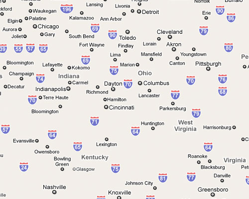
Alan Taylor has collected the longest drives that Google Maps will give driving directions for.
It turns out there are multiple “longest drives”, because the Google Maps World is partitioned (many countries don’t support driving directions), and sometimes ferries are included, and sometimes they are not.
The longest he’s found so far is from the Aleutian Islands to the tip of Newfoundland, a distance of over 7,200 miles. You can drag the path around to make it a lot longer (more than 11,000 miles) but that’s cheating.
- I’m kind of amazed that this thing lives up to the expectations I had for it. It’s an amazing device.
- To read RSS, just put a feed address into Safari and Apple redirects it through their iPhone feed reader. But it’s very much of an a la carte thing, one feed at a time. What’s needed is a proper newsreader with its own icon on home screen. Workarounds for now: Google Reader looks nice or you could make a collective feed that combines all the feeds you want to read on your iPhone and use that with the iPhone feed reader (Meg’s idea).
- I skipped the index finger and am right into the two thumb typing. With the software correction, it’s surprisingly easy. Or maybe I just have small lady thumbs.
- After fiddling with it for an hour, I know how to work the iPhone better than the Nokia I had for the past 2 years, even though the Nokia has far fewer capabilities.
- I could use the Google Maps app forever.
- When I go back to using my Macbook Pro, I want to fling stuff around the screen like on the iPhone. It’s an addictive way to interface with information.
- Finding Nemo looked really nice on the widescreen display.
- You can pinch and expand with two thumbs instead of your thumb and index finger.
- The camera is not what you would call great, but it’s as good as my old phone’s, which is about all I want out of it. The lack of video is a bit of a bummer.
- I Twittered from on line at the AT&T store that the line was moving slowly because they were doing in-store credit checks and contract sign-ups, contrary to what everyone had been told by Apple beforehand. That was not the case. They were just being super careful with everything…each phone and the bag that it went into had a bar code on it and they were scanning everything and running phones from the back of the store one at a time. The staff was helpful and courteous and it was a very smooth transaction, all things considered. I was on line for 2 hours before the store opened and then another 2 hours waiting to get into the store.
- The alert options (ringtones, vibrate options, messaging alerts, etc.) aren’t as fine-grained as I would like, but they’ll do for now.
- I have not tried the internet stuff on anything but my home WiFi network, so I don’t know about the EDGE network speed. Will try it out and about later.
- The Google Maps display shows the subway stops but not the full system map. Workaround: stick a JPG of the subway map in your iPhoto library and sync it up to the iPhone. Voila, zoomable, dragable NYC subway map.
- Wasn’t it only a year or two ago that everyone was oohing and aahing over Jeff Han’s touchscreen demos? And now there’s a mass-produced device that does similar stuff that fits it your pocket. We’re living in the future, folks…the iPhone is the hovercar we’ve all been waiting for.
Update:
- The iPhone is the first iPod with a speaker. Which means that in addition to using it as a speakerphone, you can listen to music, podcasts, YouTube videos, and movies without earphones. Which might seem a bit “eh”, but won’t once you have 15 people gathered around watching and listening to that funny bit from last night’s Colbert Report. You know, the Social.
- I’m getting my mail right off my server with IMAP, so when it gets to the phone, it hasn’t gone through Mail.app’s junk filters…which basically means that mail on the iPhone is useless for me. In the near future, I’m going to set things up to route through GMail prior to the phone to near-eliminate the spam.
- Tried the EDGE network while I was out and about. Seemed pretty speedy to me, not noticeably slower than my WiFi at home…which may say more about Time Warner’s cable modem speeds than EDGE.
- BTW, all of these first impressions are just that. You can’t judge a device or an interface without using it day to day for awhile. I’m curious to see how I and others are still liking the phone in two weeks.
- Everytime I connect the iPhone to my computer, Aperture launches. Do not want.
I’ve been keeping up with the latest iPhone news but I haven’t been telling you about it…partially because my poor pal Merlin is about to pop an artery due to all the hype. Anyway, it’s Friday and he’s got all weekend to clean that up, so here we go. The big thing is a 20-minute guided tour of the device, wherein we learn that there’s a neat swiping delete gesture, you can view Word docs, it’s thumb-typeable, the earbuds wires house the world’s smallest remote control, Google Maps have driving directions *and* traffic conditions, and there’s an “airplane mode” that turns off all the wifi, cell, and Bluetooth signals for plane trips. It looks like the iPhone will be available online…here’s the page at the Apple Store. What else? It plays YouTube videos. iPhone setup will be handled through iTunes: “To set up your iPhone, you’ll need an account with Apple’s iTunes Store.”
I’m sure this functionality is coming, but when using the new Street View feature in combination with driving directions on Google Maps, I want a play button that drives me from the starting point to my destination, showing me the street-level view along the way.
New Google Maps feature: Street View. Just place your little guy on a street on the map and up pops a 3-D panorama of what you’d see on the street. For instance, here’s a view into oncoming traffic on the Brooklyn Bridge. Only major US cities are supported for now. I remember Amazon’s A9 came out with something like this a couple of years ago, but Google’s implementation of it is fantastic. (thx, mark)
Big Box Watch is a map that displays future big box store openings in the US. The site currently tracks Best Buy, Home Depot, Ikea, JCPenney, Kohl’s, Lowe’s, Target, and Wal-Mart.
Driving directions from New York City to Dublin, Ireland, courtesy of Google Maps. Step 23: “Swim across the Atlantic Ocean. 3462 mi.” Not sure why you have to swim to France to get to Dublin, but ok. (thx, ayush)
Not sure when these features were added, but Google Maps now displays public transportation stops (NYC subway, the T in Boston, the L in Chicago) and building outlines for metropolitan areas. Here’s a shot of the West Village in NYC:
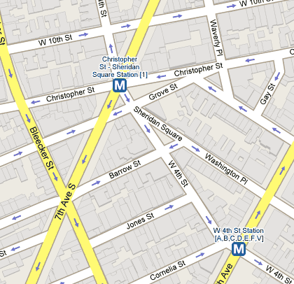
Tiny but useful improvements. (thx, meg)
Older posts
Stay Connected