I love the way she leans every
I love the way she leans every so slightly to the side as the train passes.
This site is made possible by member support. 💞
Big thanks to Arcustech for hosting the site and offering amazing tech support.
When you buy through links on kottke.org, I may earn an affiliate commission. Thanks for supporting the site!
kottke.org. home of fine hypertext products since 1998.
Beloved by 86.47% of the web.
I love the way she leans every so slightly to the side as the train passes.
In a stairway leading down to the subway platform of the N/Q Canal St. stop, a pair of doors face each other on a landing. About every three days for more than a year, I’ve seen graffiti painted on both doors. Each time, the day after the graffiti appears, so does a fresh coat of cream-colored paint. By my count, those doors are covered in at least 100 coats of paint and must be more than an inch thicker than they were last year.
Update: Probably looks something like this if you cut it open. (thx, emmet) Or this.
Subway map geeks rejoice:
Transit Maps of the World is the first and only comprehensive collection of historic and current maps of every rapid-transit system on earth. Using glorious, colorful graphics, Mark Ovenden traces the history of mass transit-including rare and historic maps, diagrams, and photographs, some available for the first time since their original publication. Transit Maps is the graphic designer’s new bible, the transport enthusiast’s dream collection, and a coffee-table essential for everyone who’s ever traveled in a city.
Found out about this from Boing Boing, where Cory has a quick review.
A tshirt featuring a subway map representation of the human gastrointestinal system. (thx, sami)
Update: Oh, and I plumb forgot the Threadless Metropolitan Cardiac Authority tshirt. (thx, sam)
The NYC Dept of Transportation is introducing compass decals to be placed on sidewalks at subway exits to help orient disembarking passengers. I thought I’d posted a link about this idea before on kottke.org, but the only reference I can find is a discussion about compasses on manhole covers. (thx, erik)
Update: Aha, here’s the entry. John has more.
Timelapse animated map of the NYC subway that shows the order of the subway lines being built. See also the history of the NYC subway, photos of the IRT’s first stations, and if you really don’t have anything else to do for the next hour or so, an extensive trove of historical NYC subway maps.
New publicly released data shows that some NYC subway lines are exceeding maximum capacity, both in terms of the number of riders per car and the number of trains per track.
Designer Eddie Jabbour is on a mission to make a new NYC subway map. The NY Times recently had a piece of Jabbour’s efforts. The new map reminds some of Massimo Vignelli’s 1972 classic map: too abstract for its own good. Here’s Vignelli talking about his map in an outtake from Helvetica and some background on the controversy surrounding it.
The top 11 underground transit systems in the world. The London Tube is #1, NYC is #7, Hong Kong is #10. (via rob)
Not sure when these features were added, but Google Maps now displays public transportation stops (NYC subway, the T in Boston, the L in Chicago) and building outlines for metropolitan areas. Here’s a shot of the West Village in NYC:
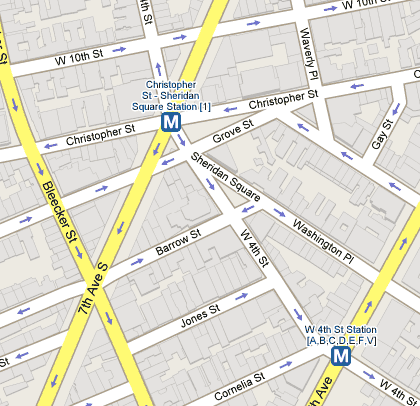
Tiny but useful improvements. (thx, meg)
Some interesting photos taken in the Moscow subway. (thx, malatron)
Walking through the Union Square subway station is like playing the Star Wars arcade game. I go through that station every single day and I never noticed that. For shame!
The Morning News has compiled a guide to NYC etiquette. See also my rules for the NYC subway.
Photos by Bill Sullivan of people going through NYC subway turnstiles. I love the moments of recognition depicted here. (via dooce)
Photos of patterns taken from public transport vehicles. Gotta make it ugly enough to hide the stains, I guess.
Wesley Autrey jumped in front of an oncoming subway train to save the life of a man who had fallen on the tracks. I read this before I left for work yesterday and imagined the scenario when my train pulled into the station. I’d hope I would do the same thing as Mr. Autrey did, but that train moves awfully fast…
A pair of trend maps for 2007, both based on subway maps. The top one depicts the top online companies/brands & how they’re connected while the bottom one deals with ideas (with the River of Consciousness standing in for the Thames).
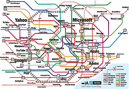
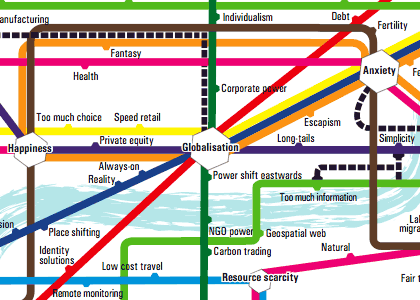
Both maps were found in this article about internet predictions in 2007. I don’t know about you, but I find these types of maps fun to look at, but completely inscrutable informationally speaking. Surely there’s a more enlightening way to present this information than in Tube map form.
Scans of the New York City Transit Authority Graphics Standards Manual from 1970. (thx, jake)
Santas riding the NYC subway in 1987. Seeing graffiti on the subway always amazes me.
Prewalking: walking down the subway platform so that when you board the train, you’ll be close to the exit or transfer point when the train reaches its destination.
Update: Photo of the Way Out -> tube map, which marks which side of the train to exit from and where exits/transfers are for each station. (thx, tom)
Update: Exit maps are available for the Toronto and Toyko subways. (thx, adam)
Where do Craigslist’s Missed Connections occur in NYC? Gawker has the breakdown by location and subway line.
A paleontology grad student, while idly inspecting a bronze cast of a dinosaur skeleton on the wall of the subway station, notices that the dinosaur in question was not cannibalistic as previously believed. Man, good science can be done *anywhere*.
Awesome Google Maps + NYC subway map combo. (via khoi)
Michael Frumin tried to get some NYC subway data from the New York City Transit Authority through Freedom Of Information Legislation for a project he wanted to do, but they denied his requests. “Given a database of anonymized Metrocard ‘swipes’ over some small period of time, Frumin imagined that a multitude of explorations could be embarked upon. Below is a concept sketch for one specific project idea — a visualization, for each station in the system, of the range of locations in the city that people travel to from that area.” Nice Minard-esque prototype map.
Taste of the New York Subway System is a directory of NYC restaurants organized by subway stop. Wow.
Morning subway demographics in NYC. Early morning blue collar workers give way to late morning white collar workers. (via capn)
Old 70s song about the subway from Sesame Street. This went totally over my head as a kid, but as a NYC resident, it’s awesome. On the subway. Subway!
Set of photos depicting NYC in the 80s. Everytime I see pictures of subway cars covered with graffiti, I marvel at how clean the cars are now.
Even native New Yorkers are often disoriented when exiting subway stations, so why doesn’t the MTA print a little direction indicator on the pavement near the exits? Better yet, download the stencils provided here and let’s do it ourselves.
Representation of the London Tube map if the stations were sponsored by products or companies. I love the Pizza Hutney, Upministry of Sound, and iPoddington stops. Rather DFWesque. (via bb)
Socials & More