Adam Yates travelled to Amsterdam to see how the Dutch have transformed the city and made it safer for people to get where they’re going more quickly. The phrase that grabbed me is:
Pedestrians, cyclists, and vehicles can all coexist without conflict, but only if they’re all going the same slow speed. This advances the principles of shared streets.
In simple terms, the Downs-Thomson paradox claims that traffic will increase without limit until the option of public transport (or any other form of transport) becomes faster than the equivalent trip by car. It draws the conclusion that people do not care whether they drive, walk, bike, or take the bus to any location — they just want to get from A to B in the fastest and most convenient way possible.
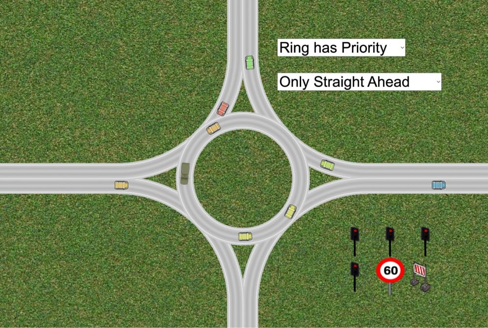
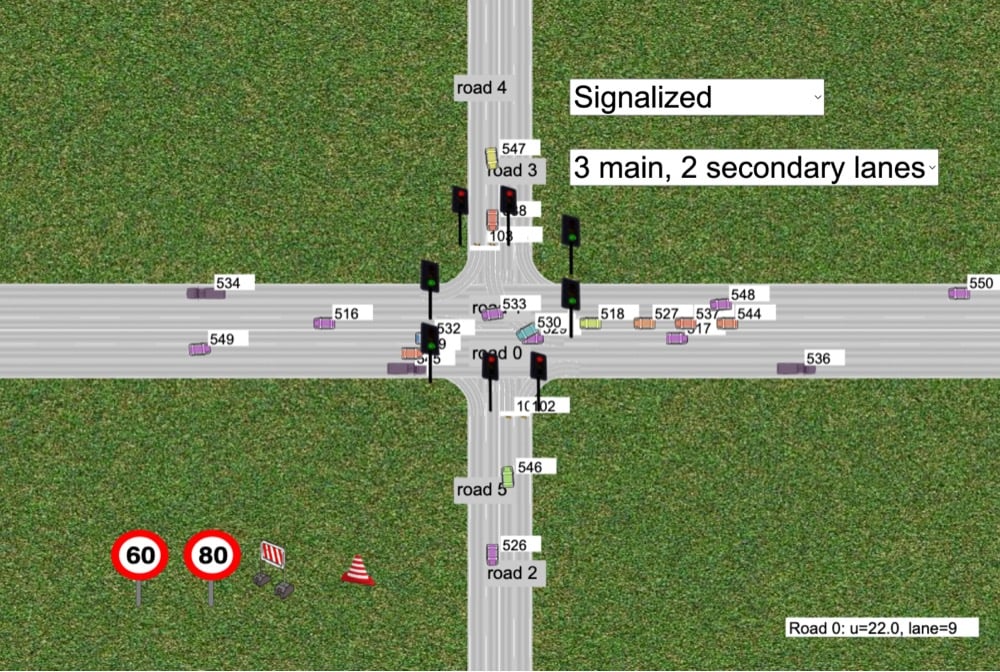
Oh wow, I spent far too much of my time this afternoon playing with this online traffic simulator. You can place stoplights, click to slow down traffic, change speed limits, modify traffic flow rates, etc. The source code for the simulator is available at Github so you can tinker with it.
I recently came across this quote from Kirkpatrick Sale’s 1980 book Human Scale and it succinctly relates a fundamental truth about the purpose of cities.
Cities are meant to stop traffic. That is their point. That is why they are there. That is why traders put outposts there, merchants put shops there, hoteliers erected inns there. That is why factories locate there, why warehouses, assembly plants and distribution centers are established there. That is why people settle and cultural institutions grow there. No one wants to operate in a place that people are just passing through; everyone wants to settle where people will stop, and rest, and look around, and talk, and buy, and share.
Cities, in short, should be an end, not a means. Rationally one wants to have traffic stop there, not go through, one wants movement within it to be slow, not fast.
Sale goes on to list four ways in which cities should think about slowing traffic down:
Cities should not try to move people to facilities but provide facilities where the people are.
Cities should be small enough so that inter-community trips, when necessary, could be managed either on foot, by bike, or with some simple subway or trolley system.
Cities should attempt to slow down the flow of traffic, particularly with plenty of squares and plazas and parks, places where wheeled vehicles are forced to halt, endpoints that invite stopping and resting.
Cities should try to bring home and workplace back together.
Update: Some alert readers let me know that Kirkpatrick Sale is a left-wing secessionist, which has brought him and his various organizations into contact & cooperation with racist hate groups and white supremacist organizations. I’m not going to link to it, but he’s written some stuff recently about how the Confederacy and slavery weren’t so bad (with tired arguments like white slave owners treating their slaves well) for an organization dedicated to exploring the “Southern tradition”. The white Southern tradition, mind you — there are no black voices or faces represented on their site as far as I can tell. I will leave it as an exercise for the reader as to whether that changes how you feel about his views on how to fix cities.1 (thx, edward & @paulbeard)
For me, it does. It’s fine to advocate for more bike transportation & workplaces close to home, but cities can accomplish that in a way that takes into account lower income communities (which in American cities are often made up of PoC and immigrants) or not. Everyone who lives in the West Village working close to their house and being able to walk to the store is fine — and perhaps if you’re Sale, you’d say “mission accomplished” — but if the restaurant busboys, teachers, shop clerks, dry cleaners, store owners, plumbers, firefighters, and all the other people that make that neighborhood actually function can’t afford to live anywhere close to the neighborhood and are still spending hours every day commuting on the subway to & from Queens, the Bronx, or Brooklyn, I would argue you really haven’t solved, or even begun to solve, the problem of moving home and workplace closer together.↩
Automobiles make up 70% of the emissions from all forms of transportation. There are an estimated 1 billion cars on the planet, with around 80 million new cars sold each year. Despite continually strong sales, experts suggest we have reached ‘Peak Car’ — meaning the average distance traveled per person in cars has peaked, and will continue to fall over time. There are many different factors contributing to this trend, such as a global shift towards urban living, new forms of mobility, new government policies for reducing traffic, and a slowing expansion of road networks.
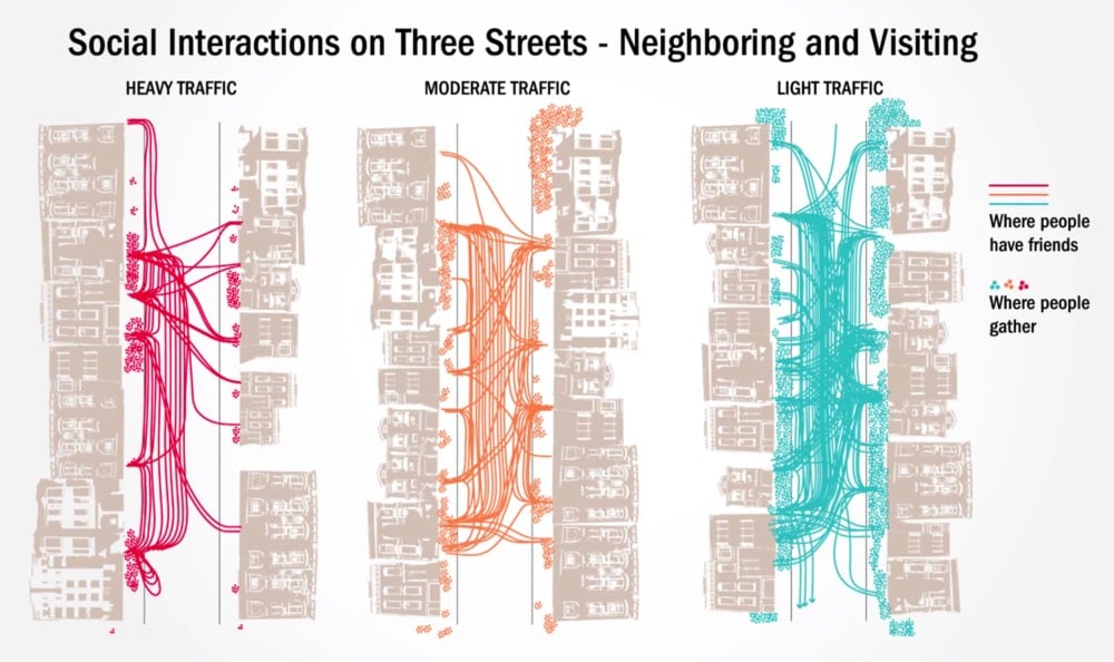
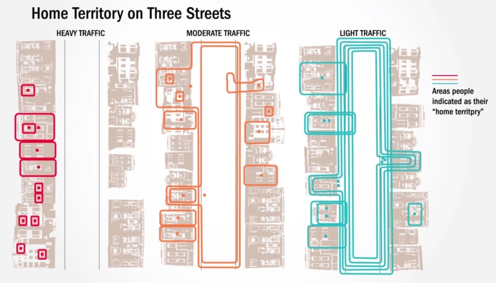
In 1981, a Berkeley urban design professor named Donald Appleyard published a book called Livable Streets (now out of print). In it, he described the results of research he’d done in the late 1960s about the effects of car traffic on the people who live in cities. For the study, he selected three similar residential streets in San Francisco that only differed in the amount of street traffic and then measured how the residents used their streets.
To illustrate his findings, Appleyard used these simple and revealing maps of the data he collected. The first map shows gathering spots on the streets and the friendships made amongst neighbors:
The second map shows what residents considered their “home territory” on their street:
What Appleyard found was that the amount of car traffic on the street dictated how friendly neighbors were with each other, how “at home” people felt in their neighborhood, and how familiar they were with their surroundings.
In the late 1960s Appleyard conducted a renowned study on livable streets, comparing three residential streets in San Francisco which on the surface did not differ on much else but their levels of traffic. The 2,000 vehicles per day street was considered Light Street, 8,000 traveled on Medium Street and 16,000 vehicles passing down Heavy Street. His research showed that residents of Light Street had three more friends and twice as many acquaintances as the people on Heavy Street.
Further, as traffic volume increases, the space people considered to be their territory shrank. Appleyard suggested that these results were related, indicating that residents on Heavy Street had less friends and acquaintances precisely because there was less home territory (exchange space) in which to interact socially.
Light Street was a closely knit community. Front steps were used for sitting and chatting, sidewalks for children to play and for adults to stand and pass the time of day, especially around the corner store, and the roadway for children and teenagers to play more active games like football. Moreover, the street was seen as a whole and no part was out of bounds.
Heavy Street, on the other hand, had little or no sidewalk activity and was used solely as a corridor between the sanctuary of individual homes and the outside world. Residents kept very much to themselves, and there was virtually no feeling of community. The difference in the perceptions and experience of children and the elderly across the two streets was especially striking.
Cars separate people from each other and so does traffic. As @wrathofgnon put it:
This was in 1969, and here we are today in 2018 still building these terrible anti-human suburbs and cities. There is no progress, and there certainly is no science, when we ignore basic common sense and even the studies that prove it.
In 1973, just a few years after Appleyard conducted his research, George Lucas’s ode to American car culture, American Graffiti, came out. Even with the gas and oil shortages in the 1970s, the sense of freedom, rebellion, and individualism depicted in American Graffiti and similar films like The French Connection, Bullitt, Smokey and the Bandit, and Cannonball Run won out over Appleyard’s attempts to show how cars wrecked the social fabric of cities. It was no contest…Americans love cars.
In a sad twist of fate, Appleyard died relatively young at 54 — he was struck and killed by a speeding car in Athens, Greece in 1982.
In the NY Times, architect and urban designer John Massengale discusses how four European cities (London, Amsterdam, Stockholm, Copenhagen) addressed their urban traffic problems and how NYC might apply those lessons to fix its own traffic issues. Massengale shared what the Dutch learned in reconfiguring their streets:
1. When drivers slow down to 20 m.p.h. or below, they are less likely to hit people and much less likely to seriously injure or kill people if they do hit them.
2. The best way to slow cars down is to throw away all the techniques that traffic engineers developed to make traffic flow quickly.
3. When you throw out all the detritus of traffic engineering, it becomes much easier to make beautiful places where people want to walk. Bike riding becomes more pleasant and safer as well.
His four-step plan to fix traffic in Manhattan is equally simple in principle:
The next step is to adopt congestion pricing below 96th Street in Manhattan and then:
1. Decrease the number of Manhattan streets that function as transportation corridors primarily devoted to moving machines through the city.
2. Design and build Slow Zones where people actually drive slowly.
3. Make the transportation corridors that remain better urban places, with a better balance between city life and moving cars.
Seems to me a vital part of this is fixing, expanding, and subsidizing the subway system…get everyone using the subway. Better, more reliable, and cheaper public transportation = less demand for taxis and Lyfts. As Bogota mayor Enrique Peñalosa said, “A developed country is not a place where the poor have cars. It’s where the rich use public transport.”
Streetmix is a nifty online street designing tool that lets you play urban transportation planner.
Design, remix, and share your street. Add bike paths, widen sidewalks or traffic lanes, learn how all of this can impact your community.
For instance, you could build a model of the street you live on, add a protected bike lane, a bike rack, or see how a road diet might affect things. You can check out what others have been doing on the Streetmix blog.
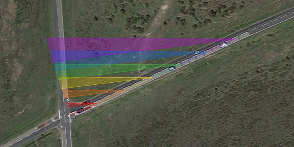
I’m a (very) amateur traffic enthusiast (see here and here for recent posts) who is fascinated by how different kinds of intersections are better than others for safety, traffic flow rates, etc. There’s a fairly normal-looking four-way intersection near Southampton that’s been the site of the deaths of two cyclists, and it turns out that geometry likely played a factor. The road is oriented such that a cyclist and a motorist approaching the intersection on the crossing roads could possibly not see each other until they collided.
Ipley Cross is constructed in such a way that not only is it possible for a careless driver to drive straight into a cyclist without seeing them until a fraction of a second before impact, but under the exact same circumstances it is also possible for that cyclist not to see the car that hits them until the same moment.
If anyone were to take a highway engineer to a wide open space and ask them to design a junction which would readily enable two road users to collide with neither of them ever seeing each other, I doubt any would be able to manage it.
Yet this is precisely what exists.
When I watch other people drive, I’m amazed at how many of them don’t take the time to look around the pillar in the front of the car…it’s such a massive blind spot. I don’t know if it’s all the driving in NYC — the right pillar perfectly obscures pedestrians stepping off the curb on a right turn — but I always check that blind spot. And a related tip for pedestrians: if you can’t see a driver’s eyes, they might not be able to see you.
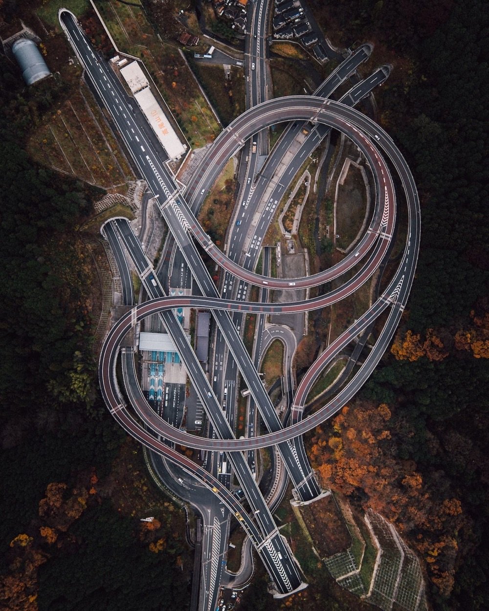
This is an animation of traffic flows simulated on 30 different kinds of four-way junctions, from two roads intersecting with no traffic lights or signs to complex stacked interchanges that feature very few interactions between individual cars. It was recorded in a game called Cities: Skylines, a more realistic take on SimCity.
The developer’s goal was to create a game engine capable of simulating the daily routines of nearly a million unique citizens, while presenting this to the player in a simple way, allowing the player to easily understand various problems in their city’s design. This includes realistic traffic congestion, and the effects of congestion on city services and districts.
I don’t know how accurate the observed rates of flow are — where my transportation engineers at? — but it’s super interesting to watch the various patterns get increasingly complex and efficient, and how the addition of dedicated turn lanes, roundabouts, overpasses, and slip lanes affect the flow. Be on the lookout for the turbo roundabout, the diverging windmill (which, coincidentally, is the name of my signature dance move), and the incredibly complex pinavia,1 which can handle almost five times the traffic flow compared to a simple intersection with no lights.
The pinavia interchange is apparently patented, which is a fascinating thing in its own right. ↩
Vox and 99% Invisible take a look at the movement to remove signs and traffic lights from traffic intersections in favor of building “shared spaces”, intersections in which cars, pedestrians, and cyclists are equally free to roam.
In traditional intersections, right-of-way has essentially been outsourced to unthinking objects like stop lights and signs. Shared spaces place the responsibility of determining right-of-way back with the individual motorists, pedestrians, and cyclists. Both approaches have their pros and cons. As the video notes, accessibility is an issue with shared spaces. But in traditional traffic schemes, cars are often given too much power to harm people, in the form of speed and the implied “I have the right-of-way so get out of my way” legal authority of the green light.
While watching traffic interact in the shared spaces in the video, you realize the assumption that makes them work: that as a general rule, people do not want to harm others. Cars, being so much more dangerous than pedestrians or cyclists, could bully their way these spaces but mostly they don’t because they don’t want to menace or injure others. However, as we’ve seen in the American political sphere recently, social norms can erode and force re-evaluation of assumptions. There will always be individual bad actors — asshole drivers or those who deliberately want to harm — but what happens to shared traffic spaces if the general assumption of people not wanting to harm others breaks down? And would traffic lights and signs fix that problem?
P.S. This is off topic (or is it?!), but I was in Amsterdam last week and it was interesting to observe the hierarchy of traffic there compared with other cities. In the absence of signs or traffic lights, who has the assumed right-of-way in these places?
In NYC (especially Manhattan), cars rule the streets, followed by pedestrians and cyclists…you only need to look at the city’s policy of not prosecuting murder-by-car to understand this. In California and esp. San Francisco (at least when I lived there years ago), if a pedestrian steps out into the street, cars will usually stop, even if they’re jaywalking. This also holds for many other places in the US, especially outside of large cities…cars are generally assumed to have the right-of-way but will also stop for pedestrians. But not in Boston…the sheer insanity of the drivers there gives cars a certain authoritative wide berth, not unlike that of a tottering Jenga tower. In Amsterdam though, cyclists seem to take priority in most situations…cars and pedestrians had to be on the lookout for them whether the cyclists had the light or not. Fascinating to observe.
The concept of road diets is an alternate approach to dealing with road congestion that’s gained popularity in recent years. The typical solution to heavy traffic on roads is to widen them with more travel lanes. The problem is such an approach can induce demand and instead of two lanes of traffic jam, you get four lanes going nowhere.1
Instead, with a road diet approach, you might turn a four-lane road into three lanes: two travel lanes and a turn lane in the middle.
Realizing these unintended outcomes, some localities implemented a type of road diet: reconfiguring the four lanes (two in each direction) into three (one each way plus a shared turn lane in the middle). The change dramatically reduced the number of “conflict points” on the road-places where a crash might occur. Whereas there might be six mid-block conflict points in a common four-lane arterial, between cars turning and merging, there were only two after the road diet.
Likewise, at an intersection, eight potential conflict points became four after a road diet.
The result was a much safer road. In small urban areas (say, populations around 17,000, with traffic volumes up to 12,000 cars a day), post-road diet crashes dropped about 47 percent. In larger metros (with populations around 269,000 and up to 24,000 daily cars), the crash reduction was roughly 19 percent. The combined estimate from all the best studies predicted that accidents would decline 29 percent, on average, after a four-to-three-lane road diet — DOT’s reported figure.
Pedestrian and bike usage tends to increase as well (b/c that extra street can be converted to bike lanes or sidewalks), speeding decreases, and car travel times are largely unaffected. This quick video by Jeff Speck shows four different approaches to road dieting:
Braess’ paradox or Braess’s paradox is a proposed explanation for a seeming improvement to a road network being able to impede traffic through it. It was discovered in 1968 by mathematician Dietrich Braess, who noticed that adding a road to a congested road traffic network could increase overall journey time, and it has been used to explain instances of improved traffic flow when existing major roads are closed.
The paradox may have analogues in electrical power grids and biological systems. It has been suggested that in theory, the improvement of a malfunctioning network could be accomplished by removing certain parts of it.
(thx, david)
Update: A street in Oakland recently underwent a road diet: two of five lanes were converted into protected bike lanes. The result is an increase in biking and pedestrian use, a decrease in collisions, a decrease in speeding, and an increase in business along the street.
Along nine blocks of Oakland’s Telegraph Avenue, biking is up 78 percent since protected bike lanes were installed. Walking is up 100 percent - maybe because, thanks to the single lane of through traffic in each direction, the pedestrian yield rate doubled in the mornings and tripled in the afternoons.
Meanwhile, the number of traffic collisions fell 40 percent. Retail sales in a district that has sometimes struggled are up 9 percent, thanks in part to five new businesses.
And the median car speed is now the speed limit: 25 mph. As usual on such projects in urban areas, the main effect of removing a car passing lane was not to jam traffic, only to prevent irresponsible drivers from weaving between lanes in order to get to the next stoplight more quickly.
What causes traffic? Mostly the poor reaction times of humans driving cars. Even a simple lane change can cause traffic to back up for hours. What’s the solution? (Hint: it rhymes with “health diving stars”.)
In 2011, Louisville converted two one-way streets near downtown, each a little more than a mile long, back to two-way traffic. In data that they gathered over the following three years, Gilderbloom and William Riggs found that traffic collisions dropped steeply — by 36 percent on one street and 60 percent on the other — after the conversion, even as the number of cars traveling these roads increased. Crime dropped too, by about a quarter, as crime in the rest of the city was rising. Property values rose, as did business revenue and pedestrian traffic, relative to before the change and to a pair of nearby comparison streets. The city, as a result, now stands to collect higher property tax revenues along these streets, and to spend less sending first-responders to accidents there.
For decades, American cities have been built around the automobile and getting them and their passengers through cities as quickly as possible. This research suggests slowing the pace of the city results in increased safety, decreased crime, and higher property values. (via mr)
I have not done an exhaustive search, but this intersection in Addis Ababa, Ethiopia has to have some of the craziest traffic in the world.
Once you get the gist of what the cars are doing, pay attention to the pedestrians. !!! My other favorite crazy traffic locale is Saigon, Vietnam…here’s how you cross the street there:
Move slowly and purposefully across the street and just let the traffic flow around you. It’s an odd sensation giving up so much control over your personal safety, but it’s the only way to cross so ¯\_(ツ)_/¯
Cars were moving too fast through an intersection in the town of Poynton in England, so they took out the stoplights & walk signals and replaced the intersection with an unusual double roundel design. The result is a mixed-use space with slower moving car traffic and safer pedestrian traffic.
3-Way Street is a fascinating video by Ron Gabriel that highlights bad interactions between cars, bikes, and pedestrians at a typical NYC street intersection.
There are lots of ways to show these interactions…the overhead view and highlighting are particularly effective design choices. Well done. (thx, janelle)
The traffic jam has sparked some entrepreneurial spirit for local residents, which has added to traffic-hostages’ annoyance. One truck driver complained that vendors were selling instant noodles for “four times the original price while I wait in the congestion.”
Tom Vanderbuilt, who wrote the book on traffic, notes that the jam is on its way to becoming a small settlement. (via mr)
Steve Jobs recently compared the shift from desktop to mobile computers to the shift from trucks to cars. You could maybe say something similar about the future of physical books compared to other kinds of media. The older forms don’t go away, but they become more specialized, and the relationships between them become different, as our lifestyles change.
Again. You could argue that the arguments we have about the cognitive effect of reading for the web are largely a replay of the upheaval surrounding mass urbanization at the turn of the century. Continuing our Metropolis theme, pull up Georg Simmel’s 1903 essay “The Metropolis and Mental Life” [PDF]. (Simmel’s German word is “Grosstadt,” which literally means “big city”; Lang deliberately used the slightly stranger, Greek-derived word to make his city feel different.) Simmel saw big cities as a tremendous economic and informational engine that fundamentally transformed human personality:
Lasting impressions, the slightness in their differences, the habituated regularity of their course and contrasts between them, consume, so to speak, less mental energy than the rapid telescoping of changing images, pronounced differences within what is grasped at a single glance, and the unexpectedness of violent stimuli. To the extent that the metropolis creates these psychological conditions - with every crossing of the street, with the tempo and multiplicity of economic, occupational and social life - it creates in the sensory foundations of mental life, and in the degree of awareness necessitated by our organization as creatures dependent on differences, a deep contrast with the slower, more habitual, more smoothly flowing rhythm of the sensory-mental phase of small town and rural existence.
And cognitive scientists have actually begun empirically verifying Simmel’s armchair psychology. And whenever I read anything about the web rewiring our brains, foretelling immanent disaster, I’ve always thought, geez, people — we live in cities! Our species has evolved to survive in every climate and environment on dry land. Our brains can handle it!
But I thought of this again this morning when a 2008 Wilson Quarterly article about planner/engineer Hans Monderman, titled “The Traffic Guru,” popped up in my Twitter feed. (I can’t even remember where it came from. Who knows why older writing just begins to recirculate again? Without warning, it speaks to us more, or differently.)
The idea that made Monderman, who died of cancer in January at the age of 62, most famous is that traditional traffic safety infrastructure—warning signs, traffic lights, metal railings, curbs, painted lines, speed bumps, and so on—is not only often unnecessary, but can endanger those it is meant to protect…
Traffic engineers, in Monderman’s view, helped to rewrite [towns] with their signs and other devices. “In the past in our villages,” Monderman said, “you could read the street in the village as a good book.” Signs advertising a school crossing were unnecessary, because the presence of a school and children was obvious. “When you removed all the things that made people know where they were, what they were a part of, and when you changed it into a uniform world,” he argued, “then you have to explain things.”
In other words, information overload, and the substitution of knowledge for wisdom. Sound familiar?
I’ll just say I remain unconvinced. We’ve largely gotten rid of pop-up ads, flashing banners, and the
[These changes] reveal themselves as one of those great historical structures in which conflicting life-embracing currents find themselves with equal legitimacy. Because of this, however, regardless of whether we are sympathetic or antipathetic with their individual expressions, they transcend the sphere in which a judge-like attitude on our part is appropriate. To the extent that such forces have been integrated, with the fleeting existence of a single cell, into the root as well as the crown of the totality of historical life to which we belong - it is our task not to complain or to condone but only to understand.
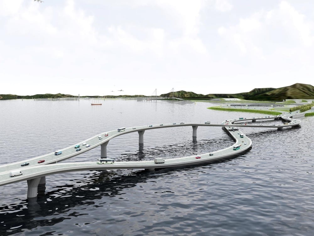
In Hong Kong, cars drive on the left while in the rest of China, they drive on the right. If you’re building a bridge between the two, you’ve got to come up with a clever way to switch lanes without disruption or accident. Behold, the flipper:
The only way that could be more cool is if one of the lanes went into a tunnel under the water or corkscrewed over the other lane in a rollercoaster/Mario Kart fashion. Lots more on the NL Architects site.
In an attempt to eliminate Manhattan’s travel inefficiencies and encourage more use of public transportation, Charles Komanoff spent three years creating an Excel spreadsheet (you can download it here) that details “the economic and environmental impact of every single car, bus, truck, taxi, train, subway, bicycle, and pedestrian moving around New York City”. Based on that research, he’s come up with a plan for changing how transportation is paid for in Manhattan below 60th St. (the CBD or central business district).
It would charge $3 to cars entering the CBD on weekday nights, $6 for most of the day, and $9 during rush hour. The subway fare also varies, but is always less than the $2.25 it is today: $1 at night, rising to $1.50 as day breaks, and peaking at $2 during weekday rush hours. Buses are always free, because the time saved when passengers aren’t fumbling for change more than makes up for the lost fare revenue. Komanoff’s plan also imposes a 33 percent surcharge on every taxi ride, 10 percent of which would go to the cab driver and the rest to the city.
Komanoff’s plan is vastly more sophisticated than a simple bridge toll. Instead of merely punishing drivers, he has built a delicate system of incentives and revenue streams. Just as a musical fugue weaves several melodic lines into a complex yet harmonious whole, Komanoff’s policy assembles all the various modes of transportation into a coherent, integrated traffic system.
The authors compared the Nash equilibrium time to the socially optimal travel time, and dubbed the ratio between the two “the price of anarchy.” In their study of the Boston area, which looked at travel times from Harvard Square to Boston Common, the price of anarchy at peak traffic times made for a journey that is 30 percent longer.
But the price of anarchy drops if you close a few roads, because individual drivers are less able to selfishly optimize their routes. In their analysis, the authors identified six streets in Boston and Cambridge: By closing those streets, they say, the optimal collective travel time would decrease between the two points.
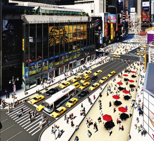
In addition to greater safety and access for pedestrians and cyclists, the project hopes to improve car traffic flow through the areas.
- Traffic lights with up to 66% more green time - Significant travel time improvements on Sixth and Seventh Avenues - Faster bus speeds for 70,000 daily riders
Here’s a rendition of how Times Square will look after the work is completed in August.
Hopefully this change will become permanent and the city can plant some trees there as well. Imagine, trees in Times Square! Lots more information is available on the DOT site.
Although it seems counterintuitive, officials believe the move will actually improve the overall flow of traffic, because the diagonal path of Broadway tends to disrupt traffic where it intersects with other streets.
The streets will become pedestrian malls instead. Love this.
If you live and work in Los Angeles and have an average commute, you spend 72 hours a year in traffic. That’s enough time to read War and Peace once, get through Wagner’s The Ring Cycle almost five times, or watch the entire Lord of the Rings trilogy almost eight times. The page includes stats for other cities too.
Update: A closer read, a bit of arithmetic, and several emails have convinced me that the 72 hours is not the overall commute time but the time spent sitting motionless in traffic. (thx, everyone)
She said the city was spending $700,000 to create the string of blocklong plazas from 42nd to 35th Streets. That includes painting the bike lane green, buying the chairs, tables, benches, umbrellas and planters and applying a coat of small-grained gravel mixed with epoxy onto the pedestrian areas, which will set them off from both the street and the bicycle path.
Looks like Bloomberg is going ahead with his battle against Manhattan car traffic without Albany’s help. I can think of several more areas that could benefit from a full or partial closure…Bleecker St would make a great pedestrian mall, as would any number of streets in Chinatown. So would St. Mark’s in the East Village. And while we’re at it, close all the streets in Central Park to cars (except the transverses).
It doesn’t get much busier than La Paz’s Plaza San Francisco of a Friday afternoon. Two zebras stand on the curb chatting with a teenage girl. Then something remarkable happens: the traffic light turns red, and at the sight of the zebras, the cars actually stop. One driver, however, is a little slow and the nose of his car is left hanging over the crossing. One of the zebras skips over to the offending car and mimes pushing it backwards. Then he continues skipping across to the other side of the street.
Stay Connected