kottke.org posts about maps
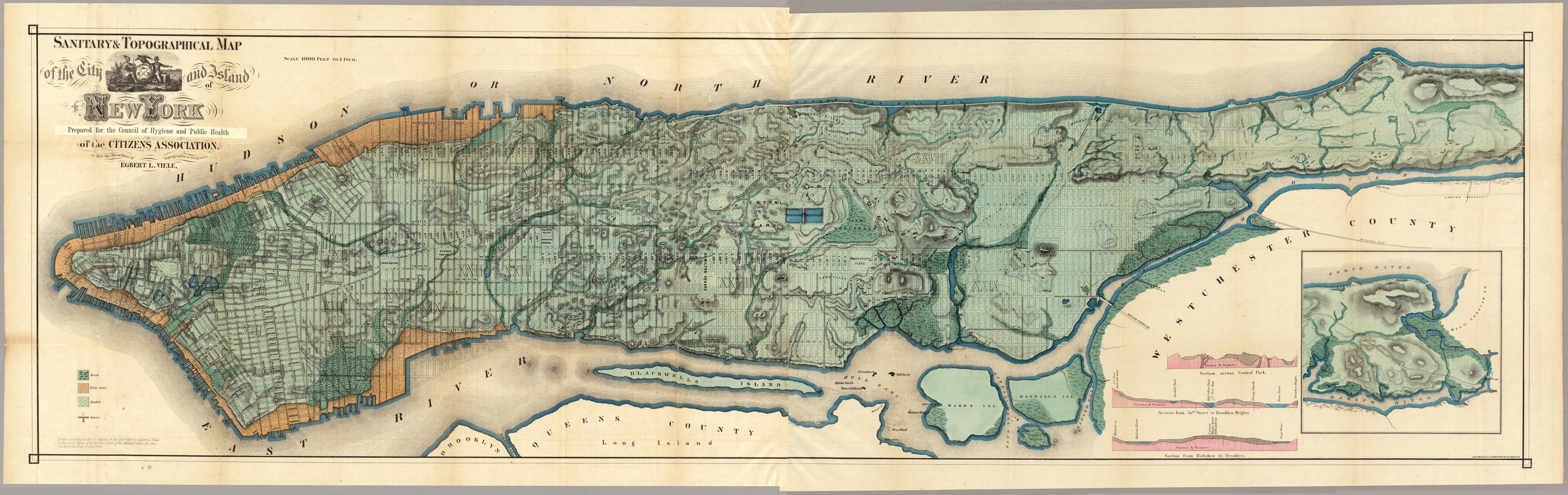
The Viele Map of Manhattan was made in 1865 and shows the original boundaries and waterways of the city. Here’s a thumbnail view (with prints for sale) and the David Rumsey Map Collection has a zoomable version that you can explore. (thx, meg)
Update: Took me forever this morning, but I cobbled together a high-res version of the Viele map from the PITA Java applet on the Rumsey site. Warning: the image is quite large (9859 x 3115, 8.6 Mb) so it might crash your browser if you attempt to look at it…better to save it to a local drive and open it up in an image viewer.
Update: Here’s a simple zoomable/scrollable version (a la Google Maps) of the high-res image that I whipped up with Zoomify. Thanks to Aaron for the suggestion.
So many New Yorkers retire to Florida, it makes sense to see what Manhattan looks like next to Miami. See also my Manhattan Elsewhere project, a map mashup featuring the island of Manhattan visiting Chicago, Boston, San Franciso, etc.
My friend Maciej found this map of NYC divided into sections that contain the same populations as other American cities. The page containing the image says it’s from an unknown “City of New York publication”. Anyone know where it’s from or where to get a better copy? Email me.
A few months ago, I found a map online (which I cannot for the life of me relocate and I’m keen to find it again…any ideas? it’s from Bill Rankin’s The Errant Isle of Manhattan…see update below) of Manhattan pasted next to Chicago, as if the island had taken up permanent residence in Lake Michigan. Recently I decided to explore the unique aspect of Manhattan’s scale with a series of similar maps of places I’ve been to or lived in: Boston, Chicago, Minneapolis, San Francisco, and Barron, WI (my hometown). Manhattan Elsewhere is the result.
Depending on your vantage point, Manhattan seems either very big or very small. On complete map of the New York City area, Manhattan is dwarfed in size by the other four boroughs and surrounding megopolis. But for someone on the ground in Manhattan, the population density, the height of the buildings, the endless number of things to do, and the fact that many people don’t often leave their neighborhoods, much less the island, for weeks/months on end makes it seem a very large place indeed. This divergence sense of scales can cause quite a bit of cognitive dissonance for residents and visitors alike.


For the top image, I used the Google Maps representations of Manhattan and Chicago to create a composite map. In the bottom image, I used Google Earth’s 3-D views to create a approximate view of Manhattan from Chicago. In all cases, Manhattan is to scale with the other cities. Click through for larger images and other cities.
Update: The map on which Manhattan Elsewhere is based was done by Bill Rankin, who runs the excellent Radical Cartography site, and is part of The Errant Isle of Manhattan project. He also did maps for Boston, SF, Door County, WI, Philly, and Los Angeles (look at how gigantic LA is!), which I completely forgot about. He also made more of an effort than I did to connect the roads. (thx, zach)
In March of 2004, an artist named Tofu began constructing a map comprised only of the hometowns of American men and women killed in Iraq (map detail). “One of the disturbing by products of this work are the maps of various states with many rectangular pieces missing where I cut out towns.” (via moon river)
Ian Albert collects really large digital images (100-900 megapixels) and constructs maps of video game worlds, including Super Mario Bros and The Legend of Zelda. (via lia)
Eyebeam’s Mike Frumin has released OGLE (OpenGL Extrator), a software package for extracting 3-D data from Windows applications. This means you can do stuff like grab the 3-D likeness of your World of Warcraft character and print it out on a 3-D printer or insert him into a Manhattan landscape (grabbed from Google Earth). Announcement here.
This blog cites a Target store advertising on Google Maps (by painting their logo on the roof), but it’s more likely that the bullseye is there for the benefit of airline passengers landing at nearby O’Hare (as this slightly wider view shows). (via bb)
Cory has calculated the center of gravity of Starbucks in Manhattan…that is, the geographic point where all of them are pulling equally on you. It’s right around 40th St and 5th Ave.
Wow, an interactive transit map for NYC. I haven’t kept up with all the Google/Yahoo Maps subway mashups, but this one is pretty impressive. Click start and end points and it tells you which subway to board and how long the trip will take, including walking time.
Good maps of Bangkok seem hard to come by. Before we left, we looked in several bookstores and decided on The Rough Guide to Bangkok. We’d never used a Rough Guide before but our usual (excellent) guidebook series, DK Eyewitness Guides, did not have a Bangkok-specific book, only a general Thailand guide. What a mistake…I’ve wanted to throw the RG right into the river about 10 times in the past few days. Meg promises me that once we get home, I can ritually set fire to it and cleanse ourselves of its crappiness.
On one of our last days here, we happened upon the Eyewitness Guide for Thailand and while it’s thick and heavy, the Bangkok section would have been perfect for our needs. Argh! Oh well…one of the difficulties in traveling is that you never know what you’re really going to need until you get to where you’re going, and that goes double for maps.
We ended up relying quite a bit on the free SkyTrain/Metro map they give you at the station, as well as a slew of free maps available at our hotel and various other places around town. None of them was very good, but depending on what we were doing, one of them had the appropriate information on it. After all this, I wonder if a good map for Bangkok even exists[1]. The city is so big and sprawling that it’s conceivable that no one has undertaken the effort to map it all.
[1] To its (possible) credit, the RG recommended a Bangkok map called Nancy Chandler’s Map of Bangkok. We found it in a small bookshop on our last full day here, and while we couldn’t properly evaluate it in its wrapper, it looked promising.
Newer posts
Older posts






Socials & More