Economist Jason Barr and his colleagues measured the bedrock depth in Manhattan and correlated it with building height. In doing so, they busted the long-held belief that there were no skyscrapers between Midtown and the Financial District because of insufficient bedrock.
What the economists found was that some of the tallest buildings of their day were built around City Hall, where the bedrock reaches its deepest point in the city, about 45 meters down, between there and Canal Street, at which point the bedrock begins to rise again toward the middle of the island. Indeed, Joseph Pullitzer built his record-setting New York World Building, a 349-foot colossus, at 99 Park Row, near the nadir, as did Frank Woolworth a decade later.
If you’ve ever been to downtown Minneapolis, you’ve likely used the large network of above-grade covered walkways that now stretches into nearly every corner of the downtown area. I’d always assumed they were built to help downtown workers and residents avoid cold weather during the winter, but that’s not the case.
Rather, the skyway system originally emerged from a twofold desire. First, planners in the 1940s and 50s were very concerned about managing increasingly dense pedestrian flows, and viewed skyways as a way to maximize the use of urban space for both people and automobiles (Byers 1998 154). Second, business owners were interested in maximizing their property values, and saw the skyways an opportunity to double the amount of valuable retail space in their downtown buildings (Byers 1998 159).
I used to work in downtown Minneapolis, and the skyways were great in the winter. To be able to take a walk and get lunch without having to bundle up in coat, hat, mittens, scarf, etc. was almost like living in a warm climate…and that’s no small thing during a long, dark Mpls winter. (via ★than)
After 36 years, Shoup’s writings — usually found in obscure journals — can be reduced to a single question: What if the free and abundant parking drivers crave is about the worst thing for the life of cities? That sounds like a prescription for having the door slammed in your face; Shoup knows this too well. Parking makes people nuts. “I truly believe that when men and women think about parking, their mental capacity reverts to the reptilian cortex of the brain,” he says. “How to get food, ritual display, territorial dominance — all these things are part of parking, and we’ve assigned it to the most primitive part of the brain that makes snap fight-or-flight decisions. Our mental capacities just bottom out when we talk about parking.”
From 1958, a piece from Fortune magazine written by Jane Jacobs called Downtown is for People.
There are, certainly, ample reasons for redoing downtown—falling retail sales, tax bases in jeopardy, stagnant real-estate values, impossible traffic and parking conditions, failing mass transit, encirclement by slums. But with no intent to minimize these serious matters, it is more to the point to consider what makes a city center magnetic, what can inject the gaiety, the wonder, the cheerful hurly-burly that make people want to come into the city and to linger there. For magnetism is the crux of the problem. All downtown’s values are its byproducts. To create in it an atmosphere of urbanity and exuberance is not a frivolous aim.
A couple years ago, I pointed to a 10-minute clip of a longer documentary called The Social Life of Small Urban Spaces. Some kind soul has put the whole thing up on Vimeo.
This witty and original film is about the open spaces of cities and why some of them work for people while others don’t. Beginning at New York’s Seagram Plaza, one of the most used open areas in the city, the film proceeds to analyze why this space is so popular and how other urban oases, both in New York and elsewhere, measure up. Based on direct observation of what people actually do, the film presents a remarkably engaging and informative tour of the urban landscape and looks at how it can be made more hospitable to those who live in it.
Dr. Munshi-South and his colleagues have been analyzing the DNA of the mice. He’s been surprised to find that the populations of mice in each park are genetically distinct from the mice in others. “The amount of differences you see among populations of mice in the same borough is similar to what you’d see across the whole southeastern United States,” he said.
I spoke to Joel Kotkin, a professor of urban development, and asked him about these surveys. “I’ve been to Copenhagen,” (Monocle’s Number 2) he tells me “and it’s cute. But frankly, on the second day, I was wondering what to do.” So, if the results aren’t to his liking, what does he suggest? “We need to ask, what makes a city great? If your idea of a great city is restful, orderly, clean, then that’s fine. You can go live in a gated community. These kinds of cities are what is called ‘productive resorts’. Descartes, writing about 17th-century Amsterdam, said that a great city should be ‘an inventory of the possible’. I like that description.”
Joel Garreau, the US urban academic and author, agrees. “These lists are journalistic catnip. Fun to read and look at the pictures but I find the liveable cities lists intellectually on a par with People magazine’s ‘sexiest people’ lists.”
Ricky Burdett, who founded the London School of Economics’ Cities Programme, says: “These surveys always come up with a list where no one would want to live. One wants to live in places which are large and complex, where you don’t know everyone and you don’t always know what’s going to happen next. Cities are places of opportunity but also of conflict, but where you can find safety in a crowd.
“We also have to acknowledge that these cities that come top of the polls also don’t have any poor people,” he adds. And that, it seems to me, touches on the big issue. Richard G Wilkinson and Kate Pickett’s hugely influential book The Spirit Level: Why More Equal Societies Almost Always Do Better (2009) seems to present an obvious truth — that places where the differential in income between the wealthiest and the poorest is smallest tend to engender a sense of satisfaction and well-being. But while it may be socially desirable, that kind of comfort doesn’t necessarily make for vibrancy or dynamism. If everybody is where they want to be, no one is going anywhere.
The researchers have shown, in fact, that with each doubling of city population, each inhabitant is, on average, 15 percent wealthier, 15 percent more productive, 15 percent more innovative, and 15 percent more likely to be victimized by violent crime regardless of the city’s geography or the decade in which you pull the data.
Remarkably, this 15 percent rule holds for a number of other statistics as well - so much so that if you tell Bettencourt and West the population of an anonymous city, they can tell you the average speed at which its inhabitants walk.
Scientists call this phenomenon “superlinear scaling.” Rather than metrics increasing proportionally with population - in a “linear,” or one-for-one fashion - measures that scale superlinearly increase consistently at a nonlinear rate greater than one for one.
“Almost anything that you can measure about a city scales nonlinearly, either showing economies in infrastructure or per capita gains in socioeconomic quantities,” Bettencourt says. “This is the reason we have cities in the first place. But if you don’t correct for these effects, you are not capturing the essence of particular places.”
Using this method, cities like LA, New York, and Houston are average while San Francisco and Boulder are above average.
Over the course of more than fifteen years, architect and critic Michael Sorkin has taken an almost daily twenty-minute walk from his apartment near Washington Square in New York’s Greenwich Village to his architecture studio further downtown in Tribeca. This walk has afforded abundant opportunities for Sorkin to reflect on the ongoing transformation of the neighbourhoods through which he passes. Inspired by events both mundane and monumental, Twenty Minutes in Manhattan unearths a network of relationships between the physical and the social city.
Here’s a chapter listing:
The Stairs
The Stoop
The Block
Washington Square
LaGuardia Place
Soho
Canal Street
Tribeca
145 Hudson Street
Alternative Routes
Espri d’Escalier
Robert Campbell, the architecture critic for the Boston Globe, says of the book:
Not since the great Jane Jacobs has there been a book this good about the day-to-day life of New York. Sorkin writes like an American Montaigne, riffing freely off his personal experience (sometimes happy, sometimes frustrating) to arrive at general insights about New York and about cities everywhere.
For a piece called Metropolis II, artist Chris Burden is building a huge track and put 1200 Hot Wheels cars on it…the noise is deafening when they’re all circulating.
It includes 1,200 custom-designed cars and 18 lanes; 13 toy trains and tracks; and, dotting the landscape, buildings made of wood block, tiles, Legos and Lincoln Logs. The crew is still at work on the installation. In “Metropolis II,” by his calculation, “every hour 100,000 cars circulate through the city,” Mr. Burden said. “It has an audio quality to it. When you have 1,200 cars circulating it mimics a real freeway. It’s quite intense.”
But the service also helps city leaders detect patterns that might otherwise have escaped notice. After the first survey of 311 complaints ranked excessive noise as the number one source of irritation among residents, the Bloomberg administration instituted a series of noise-abatement programs, going after the offenders whom callers complained about most often (that means you, Mister Softee). Similarly, clusters of public-drinking complaints in certain neighborhoods have led to crackdowns on illegal social clubs. Some of the discoveries have been subtle but brilliant. For example, officials now know that the first warm day of spring will bring a surge in use of the city’s chlorofluorocarbon recycling programs. The connection is logical once you think about it: The hot weather inspires people to upgrade their air conditioners, and they don’t want to just leave the old, Freon-filled units out on the street.
The 311 system has proved useful not just at detecting reliable patterns but also at providing insights when the normal patterns are disrupted. Clusters of calls about food-borne illness or sanitary problems from the same restaurant now trigger a rapid response from the city’s health department.
Not discussed in the article is an assertion by my pal David that exclusive access to 311 data gives incumbent politicians — like, say, Michael Bloomberg — a distinct advantage when it comes to getting reelected. For instance, when campaigning on a neighborhood level, the incumbent can look at the 311 data for each neighborhood and tailor their message appropriately, e.g. promising to help combat noise in a neighborhood with lots of noise complaints or fix the streets in a neighborhood with lots of calls about potholes.
In Singapore, many apartment buildings have empty open-air ground floors called “void decks” that get put to a variety of uses: day-care, weddings, bicycle parking, small stores, etc.
More than 80% of Singapore’s population lives in public housing, in buildings designed to government specifications. And Singapore’s government ensures that every apartment building mirrors the country’s ethnic mix, with Chinese, Malays, and Indians living as neighbors in proportion to their share of the population — 77%, 14%, and 8% respectively. The void deck ensures that everyone gets to know each other, and each other’s cultures. As the Times puts it, its pleasures are actually “part of Singapore’s strictly enforced social policies aimed at ensuring harmony among the races in a region often torn by religious and ethnic strife.”
As a diverse city that supports countless industries and maverick interests, New York excels at creating those eclectic networks. Subcultures and small businesses generate ideas and skills that inevitably diffuse through society, influencing other groups. As the sociologist Claude Fischer put it in an influential essay on subcultures published in 1975, “The larger the town, the more likely it is to contain, in meaningful numbers and unity, drug addicts, radicals, intellectuals, ‘swingers’, health-food faddists, or whatever; and the more likely they are to influence (as well as offend) the conventional center of the society.”
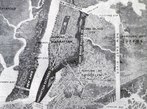
In 1916, Kennard Thomson, consulting engineer and urban planner for New York City, wrote an article for Popular Mechanics in which he advocated (among other things) filling in the East River to merge Manhattan with Brooklyn.
By Dr Thomson’s estimates, enlarging New York according to his plans would cost more than digging the Panama Canal - but the returns would quickly repay the debt incurred and make New York the richest city in the world. He then goes on to describe how he would reclaim all that land. The plan’s larger outlines: move the East River east, and build coffer dams from the Battery at Manhattan’s southern tip to within a mile of Staten Island, on the other side of the Upper Bay, and the area in between them filled up with sand. This would enlarge Manhattan to an island several times its present size.
Proximity and easy access to the new Battery would increase the total land value of Staten Island from $50 million to $500 million. “This would help pay the expenses of the project,” Dr Thomson suggests.
The project would also add large areas of land to Staten Island itself, to Sandy Hook on the Jersey shore just south of there and create a new island somewhere in between. The East River, separating Manhattan from Queens and Brooklyn, would be filled and replaced by a new canal east of there, slicing through Long Island from Flushing to Jamaica Bays.
Bikes can and should behave much more like cars than pedestrians. They should ride on the road, not the sidewalk. They should stop at lights, and pedestrians should be able to trust them to do so. They should use lights at night. And — of course, duh — they should ride in the right direction on one-way streets. None of this is a question of being polite; it’s the law. But in stark contrast to motorists, nearly all of whom follow nearly all the rules, most cyclists seem to treat the rules of the road as strictly optional. They’re still in the human-powered mindset of pedestrians, who feel pretty much completely unconstrained by rules.
The result is decidedly suboptimal for all concerned, but mostly for the bicyclists themselves. New York needs to make a collective quantum leap, from treating bicyclists like pedestrians to treating bicyclists like motorists. And unless and until it does, bike relations will continue to be marked by hostility and mistrust.
This car/pedestrian duality in the manner in which bicyclists behave is also why the City’s Summer Streets initiative is becoming almost unusable by pedestrians. We tried walking on the last Summer Streets weekend, but the cyclists were going way too fast, were routinely weaving in and out of pedestrians, pretty much refused to stay in their lanes, and there were just too many for the width of the street. We bailed out after several blocks. There will likely be even more bikes next year because the word’s getting out: it’s just too dangerous for walking.
Life in Manhattan is like living inside a gigantic Twitter stream. What you get to know about people you don’t know simply by accidental adjacency is astonishing.
Steve Jobs recently compared the shift from desktop to mobile computers to the shift from trucks to cars. You could maybe say something similar about the future of physical books compared to other kinds of media. The older forms don’t go away, but they become more specialized, and the relationships between them become different, as our lifestyles change.
Again. You could argue that the arguments we have about the cognitive effect of reading for the web are largely a replay of the upheaval surrounding mass urbanization at the turn of the century. Continuing our Metropolis theme, pull up Georg Simmel’s 1903 essay “The Metropolis and Mental Life” [PDF]. (Simmel’s German word is “Grosstadt,” which literally means “big city”; Lang deliberately used the slightly stranger, Greek-derived word to make his city feel different.) Simmel saw big cities as a tremendous economic and informational engine that fundamentally transformed human personality:
Lasting impressions, the slightness in their differences, the habituated regularity of their course and contrasts between them, consume, so to speak, less mental energy than the rapid telescoping of changing images, pronounced differences within what is grasped at a single glance, and the unexpectedness of violent stimuli. To the extent that the metropolis creates these psychological conditions - with every crossing of the street, with the tempo and multiplicity of economic, occupational and social life - it creates in the sensory foundations of mental life, and in the degree of awareness necessitated by our organization as creatures dependent on differences, a deep contrast with the slower, more habitual, more smoothly flowing rhythm of the sensory-mental phase of small town and rural existence.
And cognitive scientists have actually begun empirically verifying Simmel’s armchair psychology. And whenever I read anything about the web rewiring our brains, foretelling immanent disaster, I’ve always thought, geez, people — we live in cities! Our species has evolved to survive in every climate and environment on dry land. Our brains can handle it!
But I thought of this again this morning when a 2008 Wilson Quarterly article about planner/engineer Hans Monderman, titled “The Traffic Guru,” popped up in my Twitter feed. (I can’t even remember where it came from. Who knows why older writing just begins to recirculate again? Without warning, it speaks to us more, or differently.)
The idea that made Monderman, who died of cancer in January at the age of 62, most famous is that traditional traffic safety infrastructure—warning signs, traffic lights, metal railings, curbs, painted lines, speed bumps, and so on—is not only often unnecessary, but can endanger those it is meant to protect…
Traffic engineers, in Monderman’s view, helped to rewrite [towns] with their signs and other devices. “In the past in our villages,” Monderman said, “you could read the street in the village as a good book.” Signs advertising a school crossing were unnecessary, because the presence of a school and children was obvious. “When you removed all the things that made people know where they were, what they were a part of, and when you changed it into a uniform world,” he argued, “then you have to explain things.”
In other words, information overload, and the substitution of knowledge for wisdom. Sound familiar?
I’ll just say I remain unconvinced. We’ve largely gotten rid of pop-up ads, flashing banners, and the
[These changes] reveal themselves as one of those great historical structures in which conflicting life-embracing currents find themselves with equal legitimacy. Because of this, however, regardless of whether we are sympathetic or antipathetic with their individual expressions, they transcend the sphere in which a judge-like attitude on our part is appropriate. To the extent that such forces have been integrated, with the fleeting existence of a single cell, into the root as well as the crown of the totality of historical life to which we belong - it is our task not to complain or to condone but only to understand.
The next film in Gary Hustwit’s design trilogy (after Helvetica and Objectified) is Urbanized, an investigation of urban design.
Who is allowed to shape our cities, and how do they do it? Unlike many other fields of design, cities aren’t created by any one specialist or expert. There are many contributors to urban change, including ordinary citizens who can have a great impact improving the cities in which they live. By exploring a diverse range of urban design projects around the world, Urbanized will frame a global discussion on the future of cities.
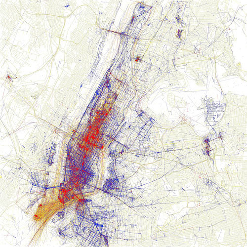
Locals and Tourists is a set of maps showing where people take photos in various cities around the world. The results are broken down into tourist photos and photos taken by locals. Here’s NYC:
Blue points on the map are pictures taken by locals (people who have taken pictures in this city dated over a range of a month or more). Red points are pictures taken by tourists (people who seem to be a local of a different city and who took pictures in this city for less than a month).
A 22-yo architecture student from The Philippines has “beaten” Sim City 3000 by building a city with the largest possible population that sustains itself for 50,000 years. The city, called Magnasanti, is not somewhere you would want to live.
There are a lot of other problems in the city hidden under the illusion of order and greatness: Suffocating air pollution, high unemployment, no fire stations, schools, or hospitals, a regimented lifestyle — this is the price that these sims pay for living in the city with the highest population. It’s a sick and twisted goal to strive towards. The ironic thing about it is the sims in Magnasanti tolerate it. They don’t rebel, or cause revolutions and social chaos. No one considers challenging the system by physical means since a hyper-efficient police state keeps them in line. They have all been successfully dumbed down, sickened with poor health, enslaved and mind-controlled just enough to keep this system going for thousands of years. 50,000 years to be exact. They are all imprisoned in space and time.
The Bloomberg administration is considering splitting 34th Street into three parts: an westbound-only section from the Hudson to 6th Ave, an eastbound-only section from 5th Ave to the East River, and a pedestrian-only section from 5th to 6th Aves.
Buses would still operate in both directions, and through the pedestrian plaza as well, but in dedicated lanes separated from passenger cars by a concrete barrier. […] A city study showed that only one in 10 people travel along 34th Street by car, including taxis; the rest walk or use mass transit. Faster buses would benefit “the majority of the people who are actually using the street”.
Twilight of the American newspaper tells the story of San Francisco and its newspapers. And in that tale, a glimpse that we might be losing our sense of place along with the newspaper.
We will end up with one and a half cities in America — Washington, D.C., and American Idol. We will all live in Washington, D.C., where the conversation is a droning, never advancing, debate between “conservatives” and “liberals.” We will not read about newlyweds. We will not read about the death of salesmen. We will not read about prize Holsteins or new novels. We are a nation dismantling the structures of intellectual property and all critical apparatus. We are without professional book reviewers and art critics and essays about what it might mean that our local newspaper has died. We are a nation of Amazon reader responses (Moby Dick is “not a really good piece of fiction” — Feb. 14, 2009, by Donald J. Bingle, Saint Charles, Ill. — two stars out of five). We are without obituaries, but the famous will achieve immortality by a Wikipedia entry.
The population [of Rome] during the Renaissance was miniscule (yet it was still a global center), when Michelangelo was painting the Sistine Chapel it was considerably smaller than a town like Palo Alto is today (60K); Rome at its nadir was about the size of Google (20K employees); the growth of Rome during the Industrial era is much greater than the rise of Ancient Rome.
David, you should check out The Inheritance of Rome; I’m about 100 pages in and pretty interesting so far. Also, it would be instructive to do the same graph but Rome’s population as a percentage of world population.
If a city doesn’t have sufficient density, as in L.A., then strange things happen. It’s human nature for us to look at one another — we’re social animals after all. But when the urban situation causes the distance between us to increase and our interactions to be less frequent we have to use novel means to attract attention: big hair, skimpy clothes and plastic surgery. We become walking billboards.
At the beginning of the 20th century, the idea of moving walkways was in vogue. After successes in Paris and Chicago, plans were drawn up for a three-speed moving sidewalk across the Brooklyn Bridge to alleviate traffic on the crowded bridge.
With the Brooklyn Bridge walkway, Schmidt upped the ante. This time he envisaged a loop system at each end of the bridge, with a series of four ever-faster walkways. Passengers moved from one to another until finally taking a seat on the benches aboard the fastest, which whisked them across the bridge at 16 km/h [~10 mph]. Because the system ran constantly, there would be no waiting and little momentum lost on stops and starts.
Note: If you are a member and tried to log in, it didn't work, and now you're stuck in a neverending login loop of death, try disabling any ad blockers or extensions. Or try logging out and then back in. Still having trouble? Email me!
Socials & More