kottke.org posts about Earth
Last year I posted a pair of videos showing a sky-stabilized rotation of the Earth around the starry sky. Because the Earth is our vantage point, we’re not used to seeing this view and it’s pretty trippy.
Now Bartosz Wojczyński has created a video showing full-day rotation of the Earth with footage shot in Namibia. The rotation is sped up to take only 24 seconds and is repeated 60 times to simulate about 2 months of rotation. I find this very relaxing to watch, like I’m riding in a very slow clothes dryer.
See also The Entire Plane of the Milky Way Captured in a Single Photo.
The first 30 seconds of this time lapse video provides a great look into how the 10 satellites that make up the Global Precipitation Measurement Constellation scan the surface of the Earth to provide daily global precipitation maps.
This visualization shows the constellation in action, taking precipitation measurements underneath the satellite orbits. As time progresses and the Earth’s surface is covered with measurements, the structure of the Earth’s precipitation becomes clearer, from the constant rainfall patterns along the Equator to the storm fronts in the mid-latitudes. The dynamic nature of the precipitation is revealed as time speeds up and the satellite data swaths merge into a continuous visualization of changing rain and snowfall.
In most time lapse videos you see of the night sky, the stars wheel through the sky as the heavens revolve around the Earth. But that perspective is really only valid from our particular frame of reference standing on the Earth. What’s actually happening is that our tiny little speck of dirt is twirling amid a galactic tapestry that is nearly stationary. And in the video above, you see just that…the Earth rotating as the camera lens stays locked on a motionless Milky Way. Total mindjob.
See also the fisheye views of the Earth rotating about the stabilized sky in this video.
Update: Another time lapse of the Earth rotating underneath the stars:
Remember how last week I told you about Eleanor Lutz’s An Atlas of Space?
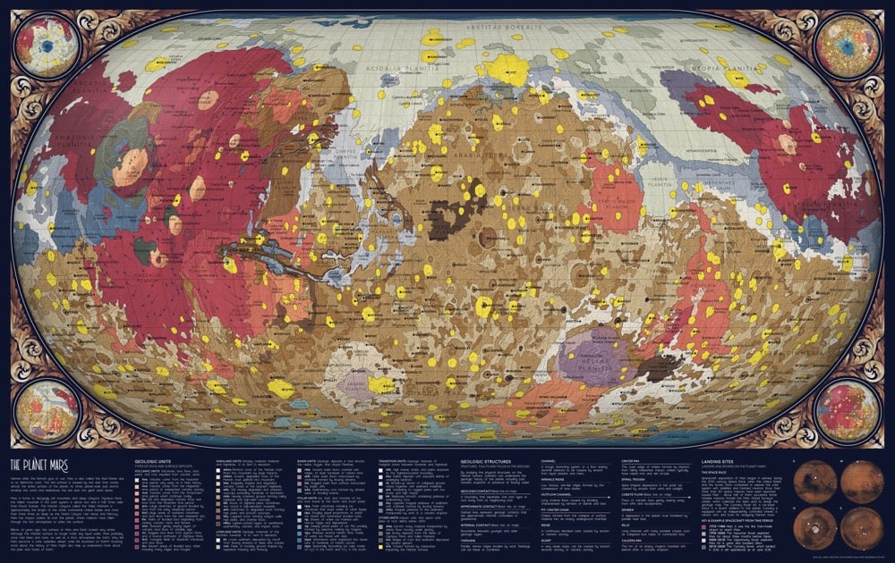
Over the past year and a half I’ve been working on a collection of ten maps on planets, moons, and outer space. To name a few, I’ve made an animated map of the seasons on Earth, a map of Mars geology, and a map of everything in the solar system bigger than 10km.
Well, she’s posted her first two projects: An Orbit Map of the Solar System (a map of more than 18,000 asteroid orbits in the solar system) and A Topographic Map of Mercury.
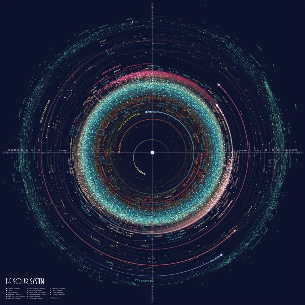
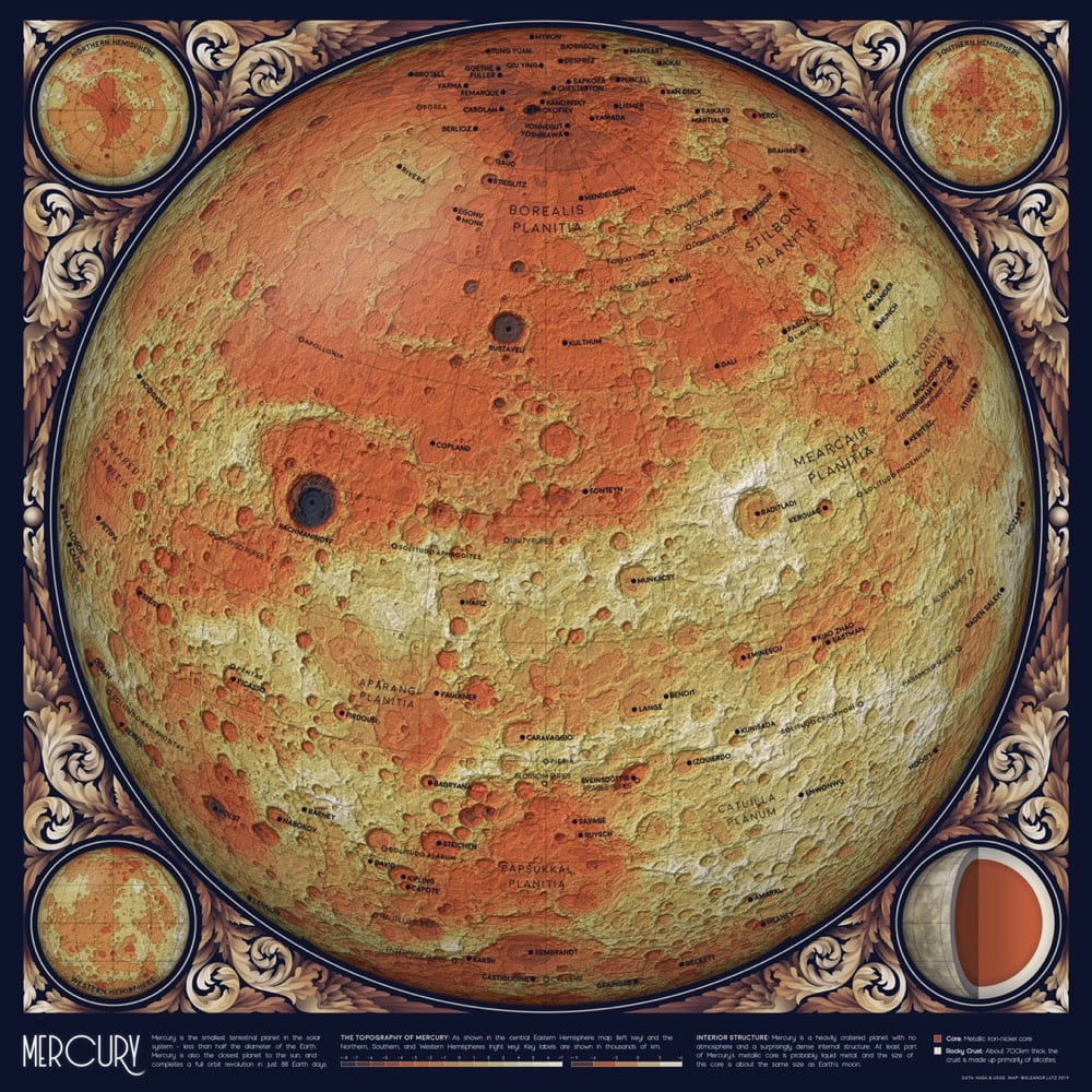
As promised, Lutz has posted the source code for each project to her GitHub account: Mercury topography, asteroid orbits. What a great resource for aspiring data visualization designers. Stay tuned to her site, Twitter, or Tumblr for upcoming installments of the atlas.
Update: Lutz’s third map in the series is out: The Geology of Mars. And here’s the link to the code and how-to on Github.
Update: Lutz’s fourth map has been released: an animated map of the Earth cycling through all four seasons. Link to the code on GitHub.
Also, she’s made high-res wallpapers available for download in a number of different aspect ratios…check out the links at the bottom of the post.
Update: Today’s installment of the atlas presents a view from our solar system: The Western Constellations (source code on Github).
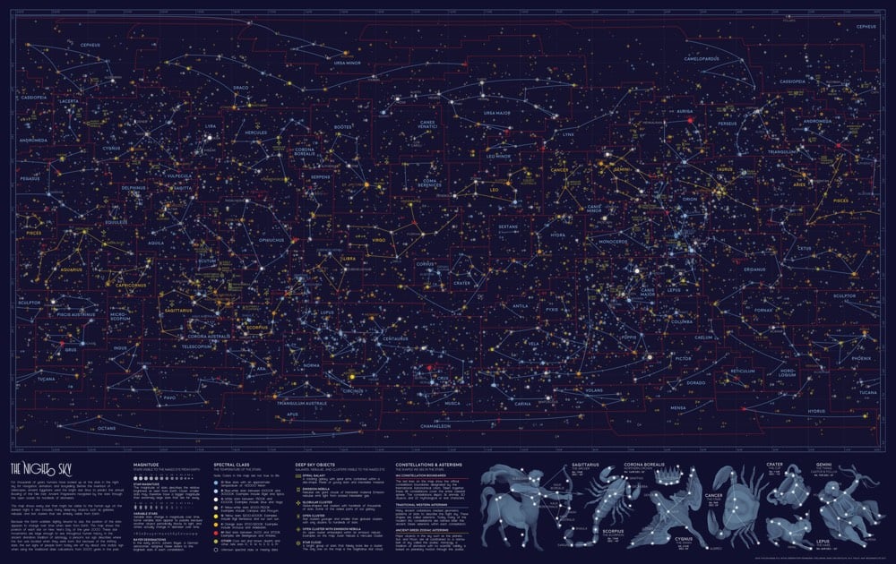
This week’s map shows every single star visible from Earth, on the darkest night with the clearest sky. The map also includes all of the brightest galaxies, nebulae, and star clusters from W.H. Finlay’s Concise Catalog of Deep-sky Objects. I illustrated the familiar Western star patterns — or asterisms — in blue and gold, as well as the scientific constellation boundaries in red.
Update: Holy moly, I think Lutz’s Topographic Map of Mars might be her most beautiful one yet.
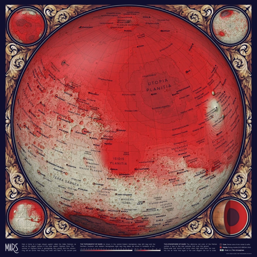
Update: I couldn’t keep up with all of Lutz’s additions to her atlas. You can check out all of the installments in the archive, including the last part (for now), The Geology of the Moon.
If you look at the orbits of the planets adjacent to the Earth’s orbit (Venus & Mars), you’ll see that Venus’s orbit is closest to our own. That is, at its closest approach, Venus gets closer to Earth than any other planet. But what about the average distance?
According to this article in Physics Today by Tom Stockman, Gabriel Monroe, and Samuel Cordner, if you run a simulation and do a proper calculation, you’ll find that Mercury, and not Venus or Mars, is Earth’s closest neighbor on average (and spends more time as Earth’s closest neighbor than any other planet):
Although it feels intuitive that the average distance between every point on two concentric ellipses would be the difference in their radii, in reality that difference determines only the average distance of the ellipses’ closest points. Indeed, when Earth and Venus are at their closest approach, their separation is roughly 0.28 AU — no other planet gets nearer to Earth. But just as often, the two planets are at their most distant, when Venus is on the side of the Sun opposite Earth, 1.72 AU away. We can improve the flawed calculation by averaging the distances of closest and farthest approach (resulting in an average distance of 1 AU between Earth and Venus), but finding the true solution requires a bit more effort.
What the calculation also shows is that Mercury is the closest planetary neighbor to every planet, on average. Also, the authors of the paper don’t explicitly mention this, but the Sun (at 1 AU) is closer on average to the Earth than even Mercury (1.04 AU).
Behind the Curve, now available on Netflix, is a 2018 documentary about the global community of people who believe that the Earth is flat. In this scene at the end of the film (um, spoilers?), a Flat-Earther named Jeran Campanella devises a simple experiment that he claims will prove that the Earth is flat…but very quickly proves the opposite:
Campanella’s reaction: “Interesting. Interesting. That’s interesting.” This is one of two straightforward experiments shown in the film that are devised by Flat-Earthers to prove the planet’s flatness that end up affirming that the Earth is indeed round (or, more accurately, an oblate spheroid).
One of the more jaw-dropping segments of the documentary comes when Bob Knodel, one of the hosts on a popular Flat Earth YouTube channel, walks viewers through an experiment involving a laser gyroscope. As the Earth rotates, the gyroscope appears to lean off-axis, staying in its original position as the Earth’s curvature changes in relation. “What we found is, is when we turned on that gyroscope we found that we were picking up a drift. A 15 degree per hour drift,” Knodel says, acknowledging that the gyroscope’s behavior confirmed to exactly what you’d expect from a gyroscope on a rotating globe.
“Now, obviously we were taken aback by that. ‘Wow, that’s kind of a problem,’” Knodel says. “We obviously were not willing to accept that, and so we started looking for ways to disprove it was actually registering the motion of the Earth.”
Knodel & Campanella are the co-hosts of a YouTube channel called Globebusters (I’m not going to link to it…YouTube’s conspiracy-minded algorithms don’t need any help) where they claim to debunk the Earth’s curvature and heliocentrism as well as discussing how NASA fakes space activities. Their failed experiments don’t seem to have diminished their Flat Earth zeal. One of their recent videos, nearly 4 hours long, is an attempt to “[debunk] the bogus claim that Globebusters proved a 15 degree per hour rotation of the Earth” and another, also almost 4 hours long, is a rebuttal to the “misrepresentation” of their views and experiments in Behind the Curve.
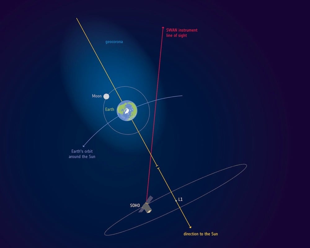
A recent analysis of data collected by the ESA/NASA Solar and Heliospheric Observatory shows that the Earth’s atmosphere is a lot larger than previously known.
A recent discovery based on observations by the ESA/NASA Solar and Heliospheric Observatory, SOHO, shows that the gaseous layer that wraps around Earth reaches up to 630 000 km away, or 50 times the diameter of our planet.
“The Moon flies through Earth’s atmosphere,” says Igor Baliukin of Russia’s Space Research Institute, lead author of the paper presenting the results.
“We were not aware of it until we dusted off observations made over two decades ago by the SOHO spacecraft.”
As you might imagine, the atmosphere gets preeeeetty thin farther from the surface of the Earth — at the Moon’s distance, the density of hydrogen atoms is 0.2 atoms per cubic centimeter.
To celebrate the 20th anniversary of the first module of the International Space Station being put into orbit, ESA astronaut Alexander Gerst shot a 15-minute time lapse video of the Earth from the ISS, long enough for two complete orbits of the planet. Landmarks along the journey are annotated right on the video and the location of the ISS is also plotted on a map in the top right corner. Love the nighttime thunderstorms over the Pacific.
See also An Incredible Video of What It’s Like to Orbit the Earth for 90 Minutes.
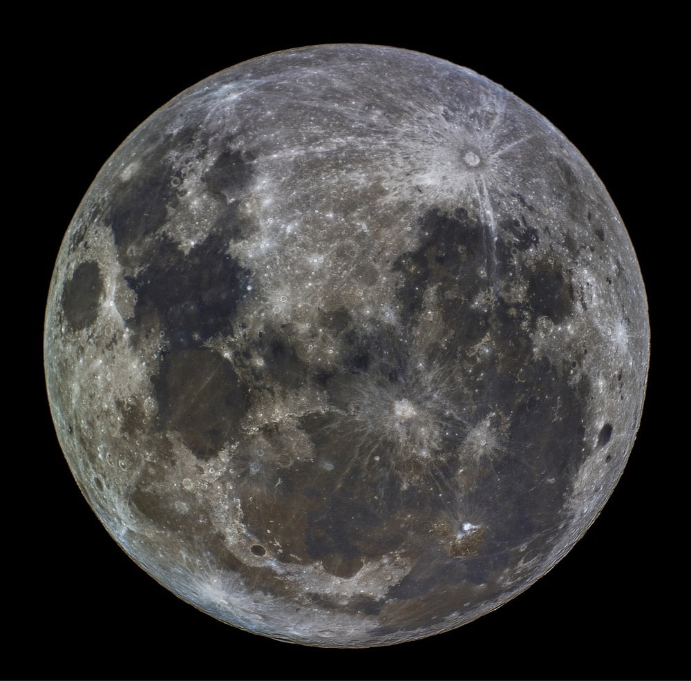
How old were you when you learned that the Moon in the Southern Hemisphere is upside down? I was today years old…this is my head exploding —> %@*&!$. Ok, the Moon isn’t upside down (that’s Northern-ist) but its orientation changes depending on if you’re north or south of the equator.
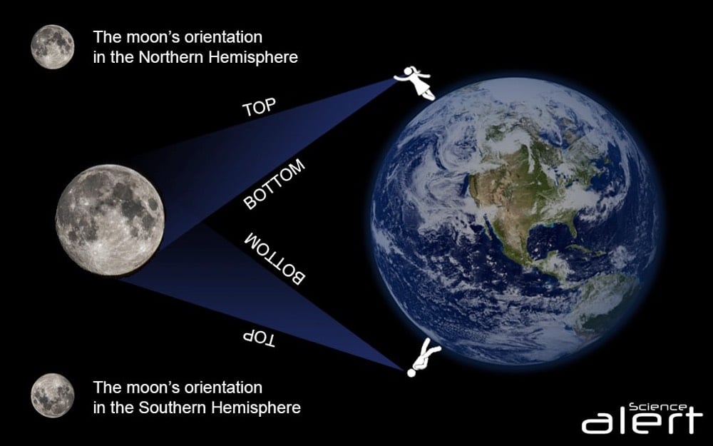
“From our perspective, the Moon and the night sky is actually rotated 180 degrees compared to our Northern Hemispherical friends,” Jake Clark, an astronomer from the University of Southern Queensland in Australia, explained to ScienceAlert.
“In the south we see the Moon’s dark ‘Oceanus Procellarum’ sea in the south-east corner compared to in the north-west corner for a northern observer.”
But why does it look like this? Well, because physically, we’re actually upside down compared to someone standing in the opposite hemisphere.
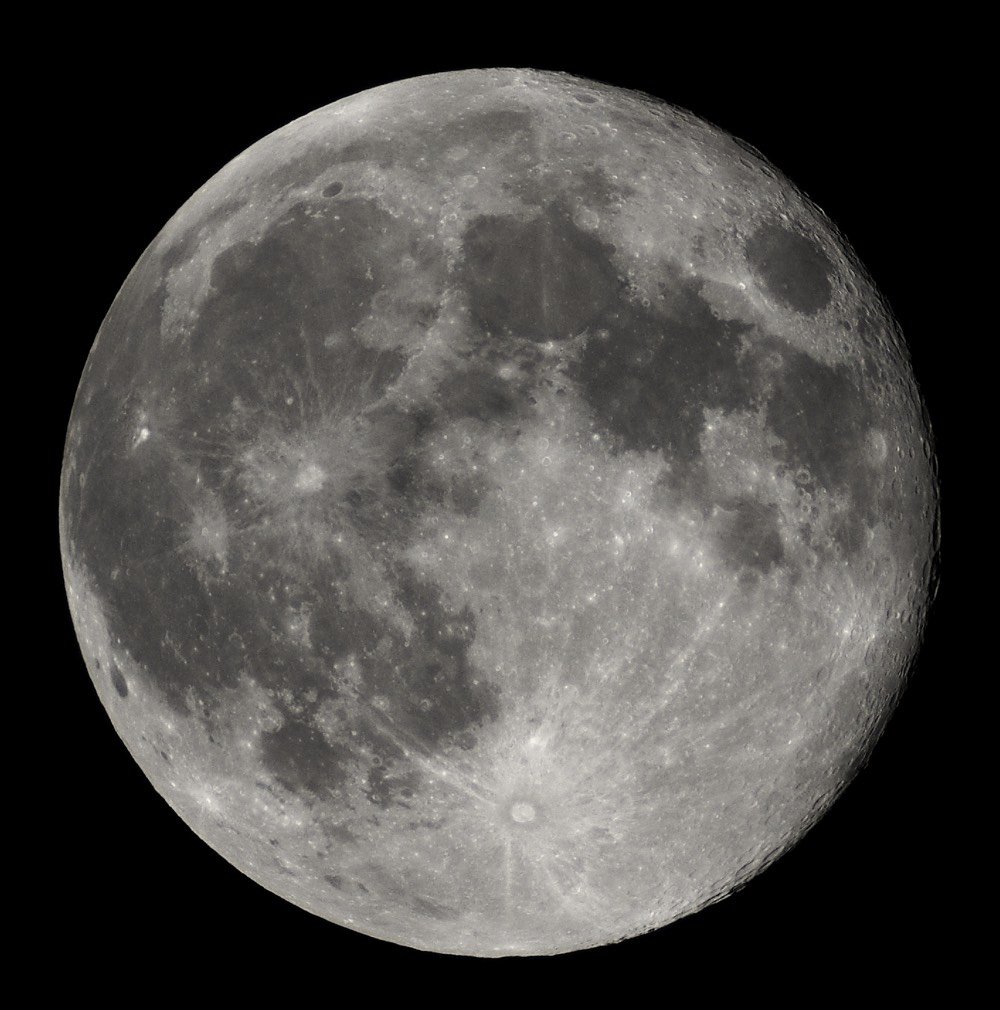
That makes perfect sense & the explanation is quite simple but it’s still messing with my head. How did I not know this? Here’s how the Moon appears in the Northern Hemisphere (from Wikipedia):
And here’s a photo from Brendan Keene in Australia:
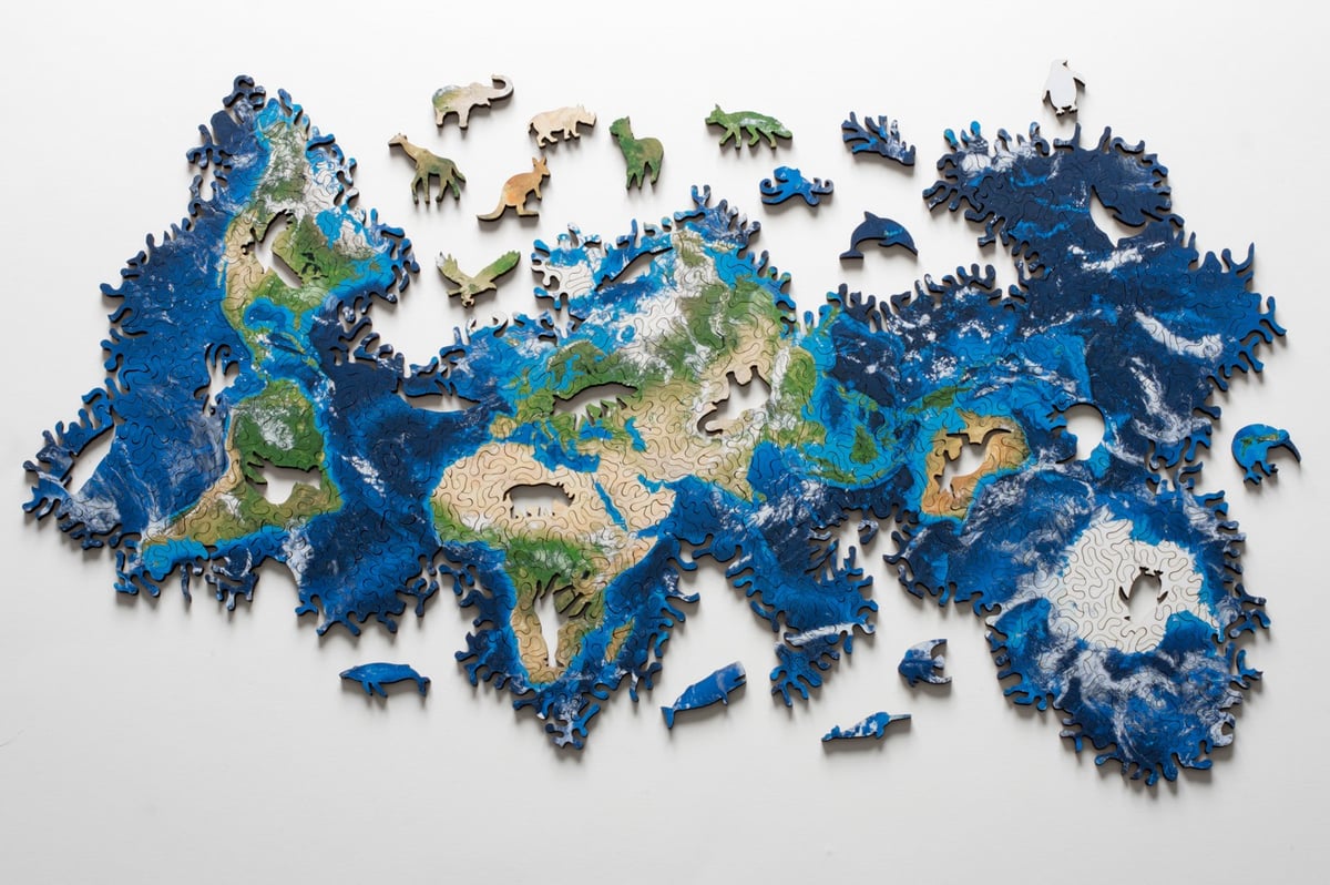
Nervous System designed this puzzle of Earth so that it can be put together in a variety of different ways.
This puzzle is based on an icosahedral map projection and has the topology of a sphere. This means it has no edges, no North and South, and no fixed shape. Try to get the landmasses together or see how the oceans are connected. Make your own maps of the earth!
This is easily the most awe-inspiring and jaw-dropping thing I’ve seen in months. In its low Earth orbit ~250 miles above our planet, the International Space Station takes about 90 minutes to complete one orbit of the Earth. Fewer than 600 people have ever orbited our planet, but with this realtime video by Seán Doran, you can experience what it looks like from the vantage point of the IIS for the full 90 minutes.
The video is in 4K so find the largest monitor/TV you can, turn up the sound, watch for awhile (even if it’s only for a few minutes), and see if you don’t experience a little bit of the Overview Effect, what NASA astronaut Kathryn Sullivan described as a life-altering experience:
I first saw the earth — the whole earth — from the shuttle Challenger in 1984. The view takes your breath away and fills you with childlike wonder. An incredibly beautiful tapestry of blue and white, tan, black and green seems to glide beneath you at an elegant, stately pace. But you’re actually going so fast that the entire map of the world spins before your eyes with each 90-minute orbit. After just one or two laps, you feel, maybe for the first time, like a citizen of a planet.
We could use more global citizenry these days.
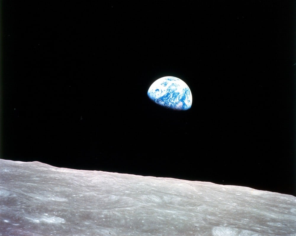
In 1968, the crew of Apollo 8 became the first ever humans to leave the cozy confines of Earth orbit. From Wikipedia:
The three-astronaut crew — Commander Frank Borman, Command Module Pilot James Lovell, and Lunar Module Pilot William Anders — became the first humans to travel beyond low Earth orbit; see Earth as a whole planet; enter the gravity well of another celestial body (Earth’s moon); orbit another celestial body (Earth’s moon); directly see the far side of the Moon with their own eyes; witness an Earthrise; escape the gravity of another celestial body (Earth’s moon); and re-enter the gravitational well of Earth.
That’s a substantial list of firsts. But before setting out on the mission, neither the crew or anyone else at NASA gave much thought to perhaps the most significant and long-lasting achievements on that list: “see Earth as a whole planet” and “witness an Earthrise”. In this gem of a short film by Emmanuel Vaughan-Lee, Anders, Borman, and Lovell recall what it was like for them to be the first of only 24 people to see, with their own eyes, the Earth from that distance, a blue marble hanging in the inky blackness of space.
What they should have sent was poets, because I don’t think we captured the grandeur of what we’d seen.
The day after Apollo 8 orbited the Moon, a poem by Archibald Macleish published on the front page of the NY Times tried to capture that grandeur: Riders on Earth Together, Brothers in Eternal Cold.
Men’s conception of themselves and of each other has always depended on their notion of the earth. When the earth was the World — all the world there was — and the stars were lights in Dante’s heaven, and the ground beneath men’s feet roofed Hell, they saw themselves as creatures at the center of the universe, the sole, particular concern of God — and from that high place they ruled and killed and conquered as they pleased.
And when, centuries later, the earth was no longer the World but a small, wet spinning planet in the solar system of a minor star off at the edge of an inconsiderable galaxy in the immeasurable distances of space — when Dante’s heaven had disappeared and there was no Hell (at least no Hell beneath the feet) — men began to see themselves not as God-directed actors at the center of a noble drama, but as helpless victims of a senseless farce where all the rest were helpless victims also and millions could be killed in world-wide wars or in blasted cities or in concentration camps without a thought or reason but the reason — if we call it one — of force.
Now, in the last few hours, the notion may have changed again. For the first time in all of time men have seen it not as continents or oceans from the little distance of a hundred miles or two or three, but seen it from the depth of space; seen it whole and round and beautiful and small as even Dante — that “first imagination of Christendom” — had never dreamed of seeing it; as the Twentieth Century philosophers of absurdity and despair were incapable of guessing that it might be seen. And seeing it so, one question came to the minds of those who looked at it. “Is it inhabited?” they said to each other and laughed — and then they did not laugh. What came to their minds a hundred thousand miles and more into space — “half way to the moon” they put it — what came to their minds was the life on that little, lonely, floating planet; that tiny raft in the enormous, empty night. “Is it inhabited?”
The medieval notion of the earth put man at the center of everything. The nuclear notion of the earth put him nowhere — beyond the range of reason even — lost in absurdity and war. This latest notion may have other consequences. Formed as it was in the minds of heroic voyagers who were also men, it may remake our image of mankind. No longer that preposterous figure at the center, no longer that degraded and degrading victim off at the margins of reality and blind with blood, man may at last become himself.
To see the earth as it truly is, small and blue and beautiful in that eternal silence where it floats, is to see ourselves as riders on the earth together, brothers on that bright loveliness in the eternal cold — brothers who know now they are truly brothers.
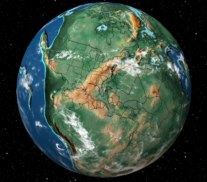
This is fun to play with: Dinosaur Pictures has a Google Earth-style globe that shows the state of the planet at various intervals 20 million, 200 million, or 750 million years ago, with plenty of stops in between. You can watch India collide into the rest of Asia, or jump to the birth (and death) of dinosaurs, the first flowers, the first hominids, etc. And you can watch the whole planet or zero in on an individual contemporary address.
One point of view that I found oddly soothing: the middle of the Pacific Ocean. All over the planet, millions of years are passing by, transforming the land-bound flora and fauna through tectonic and climatic upheavals, and the ocean just… stays the ocean. Big things are happening below the surface, but the biggest part of the planet just continues to be this deep blue, undisturbed marble.
Humans are so small compared to the size of the Earth, it’s sometimes difficult to comprehend the scale of things like, say, the massive meteorite that struck the Yucatan peninsula about 66 million years ago, an event that triggered the mass extinction of plants and animals, including the dinosaurs. In his recent book, The Ends of the World, Peter Brannen takes a crack at explaining just how big the meteorite was and how quickly the event occurred.
“The meteorite itself was so massive that it didn’t notice any atmosphere whatsoever,” said Rebolledo. “It was traveling 20 to 40 kilometers per second, 10 kilometers — probably 14 kilometers — wide, pushing the atmosphere and building such incredible pressure that the ocean in front of it just went away.”
These numbers are precise without usefully conveying the scale of the calamity. What they mean is that a rock larger than Mount Everest hit planet Earth traveling twenty times faster than a bullet. This is so fast that it would have traversed the distance from the cruising altitude of a 747 to the ground in 0.3 seconds. The asteroid itself was so large that, even at the moment of impact, the top of it might have still towered more than a mile above the cruising altitude of a 747. In its nearly instantaneous descent, it compressed the air below it so violently that it briefly became several times hotter than the surface of the sun.
“The pressure of the atmosphere in front of the asteroid started excavating the crater before it even got there,” Rebolledo said. “Then when the meteorite touched ground zero, it was totally intact. It was so massive that the atmosphere didn’t even make a scratch on it.”
Unlike the typical Hollywood CGI depictions of asteroid impacts, where an extraterrestrial charcoal briquette gently smolders across the sky, in the Yucatan it would have been a pleasant day one second and the world was already over by the next. As the asteroid collided with the earth, in the sky above it where there should have been air, the rock had punched a hole of outer space vacuum in the atmosphere. As the heavens rushed in to close this hole, enormous volumes of earth were expelled into orbit and beyond — all within a second or two of impact.
“So there’s probably little bits of dinosaur bone up on the moon,” I asked.
“Yeah, probably.”
I don’t know if your eyes are as wide as mine are about now but…
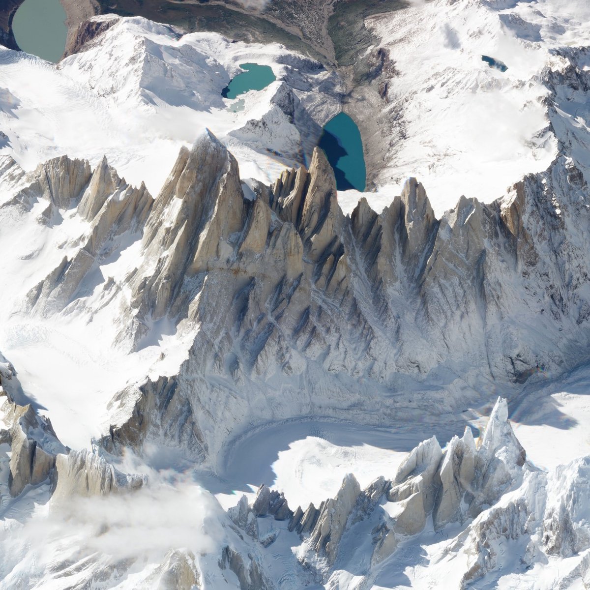
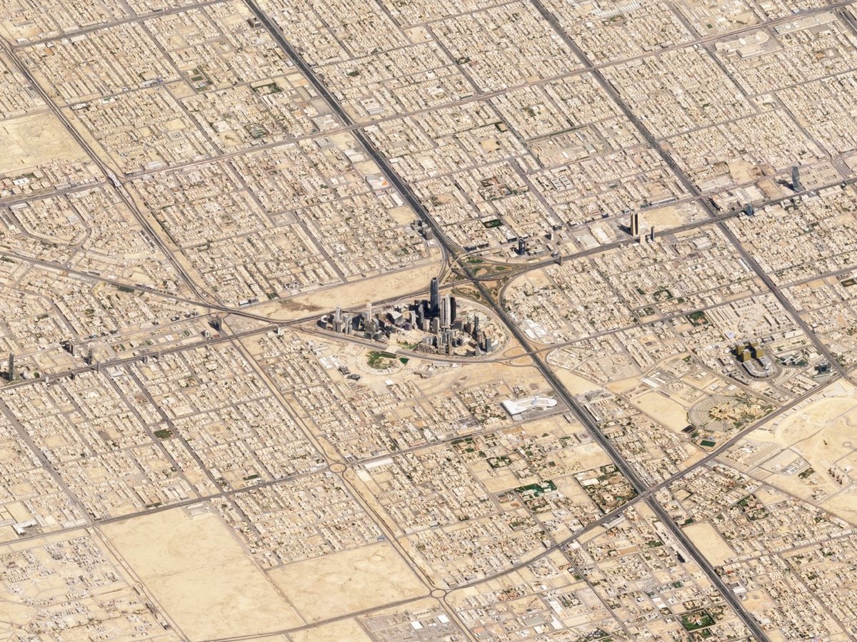
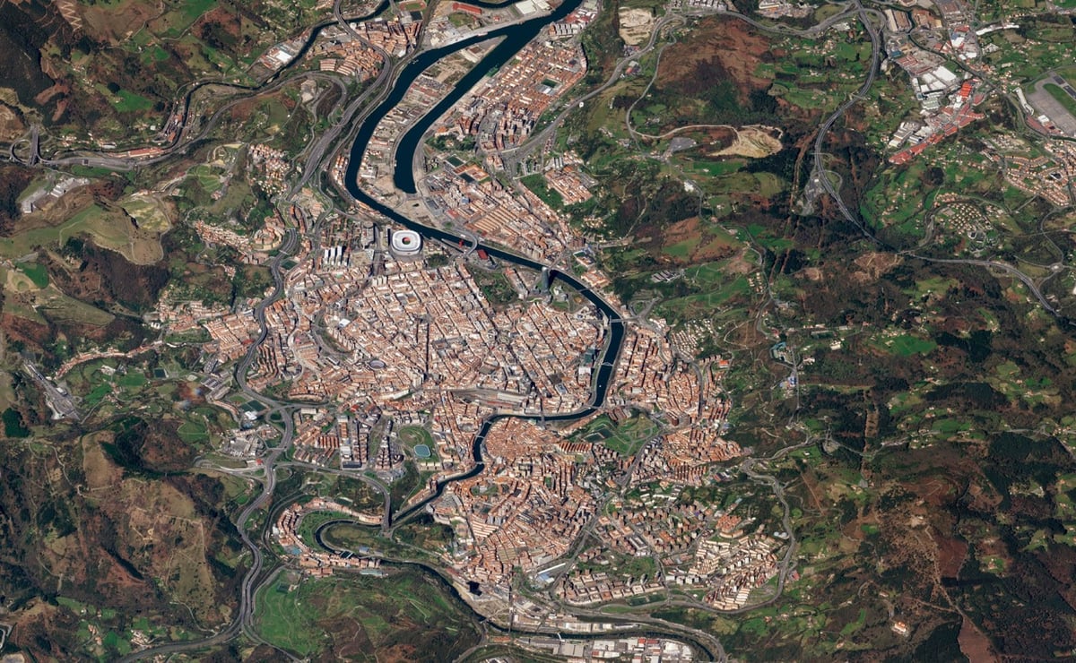
Planet Labs has published a selection of satellite images taken at an angle rather than the more familiar straight-down view.
Once a matter of debate, we know today the Earth is not flat. But the satellite imagery we’re most familiar with — taken straight down — flattens and obscures the visual cues we get from perspective, making the imagery appear like maps, not photos.
Take for example this nadir view of Monte Fitz Roy. You might not appreciate that these are mountains unless you spot the clue in the jagged shadows coming off the mountain’s serrated summits.
When you take an image of Monte Fitz Roy from an angle, the view becomes altogether different: the mountains rise to their commanding height, valleys regain their depth, and background features recede into the distance. It’s like getting a view out the window of an airplane 450 kilometers high.
Newer posts
Older posts





Socials & More