An Extremely Detailed Map of New York City Neighborhoods
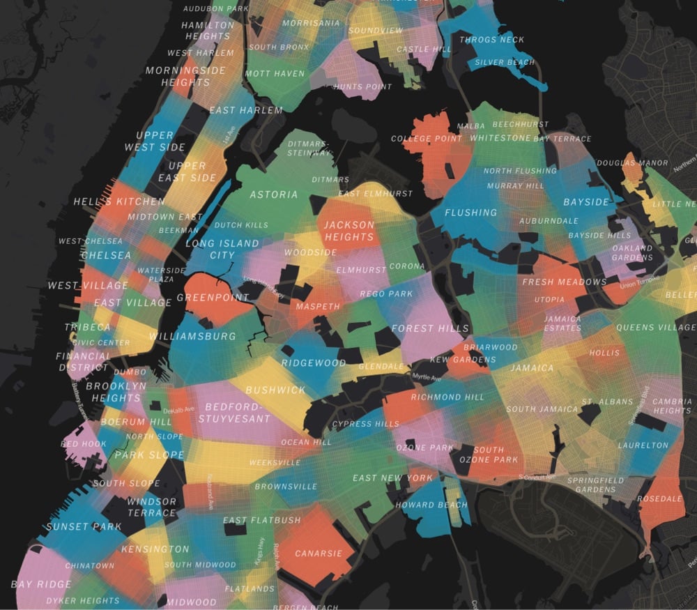
Using survey data, responses from community boards & city council members, and over 37,000 responses from NYC residents, a team at the NY Times has made a detailed map of the 350+ distinct neighborhoods in NYC. From a companion article:
It’s a New York pastime to gripe that neighborhoods are invented and defined by real estate brokers, developers and other city gatekeepers. But the more interesting truth may be that they are also reinvented and reinforced, refracted through race and class, by us: by the air traffic controller who lives in Little Yemen, by the Manhattan community manager who’s sure his constituents live in East Harlem — and not “Upper Carnegie Hill” — and by the Brooklyn residents who decided to name a relatively flat piece of land Boerum Hill.
A name has power. It can foreshadow who will be moving in. By itself, it can conjure so much: gentrification, displacement, inequality, status. When we argue over names, or even invent new ones, we may be trying to exert some of that power — or lamenting that others have more power than we do.
We asked New Yorkers themselves to map their neighborhoods and to tell us what they call them. The result, while imperfect, is probably the most detailed map of the city’s neighborhoods ever compiled.
The article is interesting throughout:
Our map reveals two main kinds of divisions: sharp ones and fuzzy ones.
The fuzzy ones often reflect areas in transition or dispute, where there’s no consensus or where gentrification is rewriting boundaries in real time.
The sharp ones often reflect features of the landscape itself: wide avenues, highways, remnants of canals. When you cross the street, you know you’re in another neighborhood.
Next time I’m in NYC, I’m definitely going to Little Yemen for lunch.
Discussion 4 comments
I had not heard of Little Yemen! Before clicking, I had assumed this was in reference to a stretch of Atlantic Avenue in Brooklyn. Please report on any places you visit.
This map is fascinating. I live in Greenwich Village and have the age-old debate with neighbors about where the West Village starts. 65% of folks agree with me for our block.
I absolutely love this thing … hopefully not only because it makes me feel even more right about some of my cranky New York opinions (ie where Park Slope ends, or the parts of Woodside that are actually Sunnyside) 😅
I spend every week visiting and photographing a different NYC neighborhood for a project I’m currently working on and this map is a godsend. I’m constantly trying to figure out where one neighborhood ends and another begins, and this map, with its amorphous borders is perfect.
Up to this point I’ve been using a map I ordered from nyc.gov for a reference. There is also a PDF of the map here. Its nice to have a physical map you can stick a pushpin in, but still nowhere near as neat as this NYT map.
Hello! In order to leave a comment, you need to be a current kottke.org member. If you'd like to sign up for a membership to support the site and join the conversation, you can explore your options here.
Existing members can sign in here. If you're a former member, you can renew your membership.
Note: If you are a member and tried to log in, it didn't work, and now you're stuck in a neverending login loop of death, try disabling any ad blockers or extensions that you have installed on your browser...sometimes they can interfere with the Memberful links. Still having trouble? Email me!
In order to leave a comment, you need to be a current kottke.org member. Check out your options for renewal.
This is the name that'll be displayed next to comments you make on kottke.org; your email will not be displayed publicly. I'd encourage you to use your real name (or at least your first name and last initial) but you can also pick something that you go by when you participate in communities online. Choose something durable and reasonably unique (not "Me" or "anon"). Please don't change this often. No impersonation..
Note: I'm letting folks change their display names because the membership service that kottke.org uses collects full names and I thought some people might not want their names displayed publicly here. If it gets abused, I might disable this feature.
If you feel like this comment goes against the grain of the community guidelines or is otherwise inappropriate, please let me know and I will take a look at it.
This thread is closed for new comments & replies. Thanks to everyone for participating!