Millions of years ago, the supercontinent of Pangea slowly started to break apart into the continents we all live on today. In this video from the makers of ArcGIS mapping software, you can watch as the reconfiguration of the Earth’s land happens over 200 million years.
Damn, India slammed into Asia like the Kool-aid Man — no wonder the Himalayas are so tall!
Once, the craggy limestone peaks that skim the sky of Everest were on the ocean floor. Scientists believe it all began to change about 200 million years ago — at around the time the Jurassic dinosaurs were beginning to emerge — when the supercontinent of Pangea cracked into pieces. The Indian continent eventually broke free, journeying north across the vast swathe of Tethys Ocean for 150 million years until it smacked into a fellow continent — the one we now know as Asia — around 45 million years ago.
The crushing force of one continent hitting another caused the plate beneath the Tethys Ocean, made of oceanic crust, to slide under the Eurasian plate. This created what is known as a subduction zone. Then the oceanic plate slipped deeper and deeper into the Earth’s mantle, scraping off folds limestone as it did so, until the Indian and Eurasian plates started compressing together. India began sliding under Asia, but because it’s made of tougher stuff than the oceanic plate it didn’t just descend. The surface started to buckle, pushing the crust and crumples of limestone upwards.
And so the Himalayan mountain range began to rise skyward. By around 15-17 million years ago, the summit of Everest had reached about 5,000m (16,404ft) and it continued to grow. The collision between the two continental plates is still happening today. India continues to creep north by 5cm (2in) a year, causing Everest to grow by about 4mm (0.16in) per year (although other parts of the Himalayas are rising at around 10mm per year [0.4in]).
See also Map of Pangaea with Modern-Day Borders, How the Earth’s Continents Will Look 250 Million Years From Now, and Locate Modern Addresses on Earth 240 Million Years Ago. (via open culture)
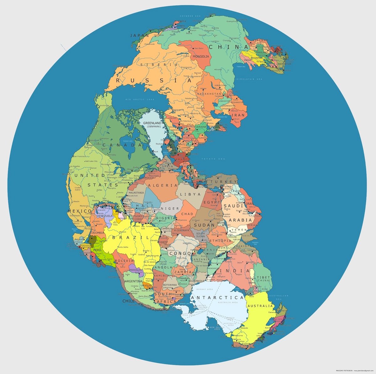
Pangaea is a supercontinent that formed on Earth about 335 million years ago and began to break up about 175 million years ago, eventually forming the familiar continents of today. Massimo Pietrobon made a map that shows where our modern country borders would appear on Pangaea. Check out the full-size version here.
See also Locate Modern Addresses on Earth 240 Million Years Ago. (via @owacle)
Speaking of Pangaea, this video shows how the present-day continents came to be formed from the Pangaea supercontinent about 240 million years ago, then shows what the Earth’s surface might look like 250 million years in the future, if the tectonic plates continue to move in predictable ways.
I hope this explanation is helpful. Of course all of this is scientific speculation, we will have to wait and see what happens, but this is my projection based on my understanding of the forces that drive plate motions and the history of past plate motions. Remember: “The past reveals patterns; Patterns inform process; Process permits prediction.”
Look at how quickly India slams into the Asian continent…no wonder the Himalayas are so high.1 And it’s interesting that we’re essentially bookended by two supercontinents, the ancient Pangaea and Pangaea Proxima in the future.
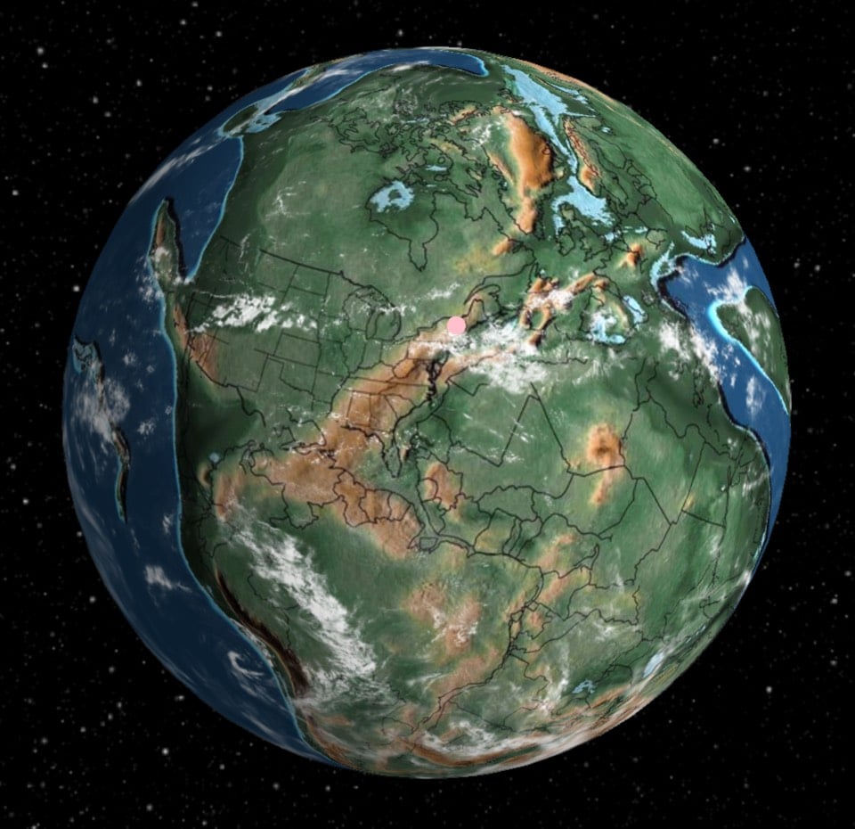
Ian Webster built a tool to plot modern addresses on a map of the Earth from up to 750 million years ago. Just input an address and it’ll find where that spot of land was on the Earth at a given time. The tool defaults to a view from 240 million years ago, smack in the middle of the Pangaea supercontinent era, but you can select views from 750 million years ago right up to the present. Webster explained a bit about the project on Hacker News:
I built this by adapting GPlates (https://www.gplates.org), an academic project providing desktop software for geologists to investigate plate tectonic data. I’m amazed that geologists collected enough data to actually plot my home 750M years ago, so I thought you all would enjoy it too.
Even though plate tectonic models return precise results, you should consider the plots approximate (obviously we will never be able to prove correctness). In my tests I found that model results can vary significantly. I chose this particular model because it is widely cited and covers the greatest length of time.
The visualization is open source and Webster is working on integrating the plate techtonics and location data into that repo soon.
Socials & More