kottke.org posts about 2012 election
Because of the Electoral College and the way the primary system works in the US, presidential candidates end up spending a disproportionate amount of time is so-called “battleground states” like Pennsylvania, Ohio, and our dysfunctional friend Florida and primary states like Iowa and New Hampshire and less time where most of the US population actually lives (NY, CA, TX, IL, and in cities). The campaign for the National Popular Vote has produced a map that shows where the candidates did campaign events in 2016:
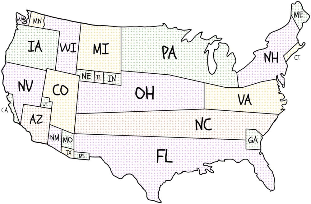
Because of these state winner-take-all statutes, presidential candidates have no reason to pay attention to the issues of concern to voters in states where the statewide outcome is a foregone conclusion. In 2012, as shown on the map, all of the 253 general-election campaign events were in just 12 states, and two-thirds were in just 4 states (Ohio, Florida, Virginia, and Iowa). Thirty-eight states were completely ignored.
And here’s the map for the 2012 election, which is even more extreme:
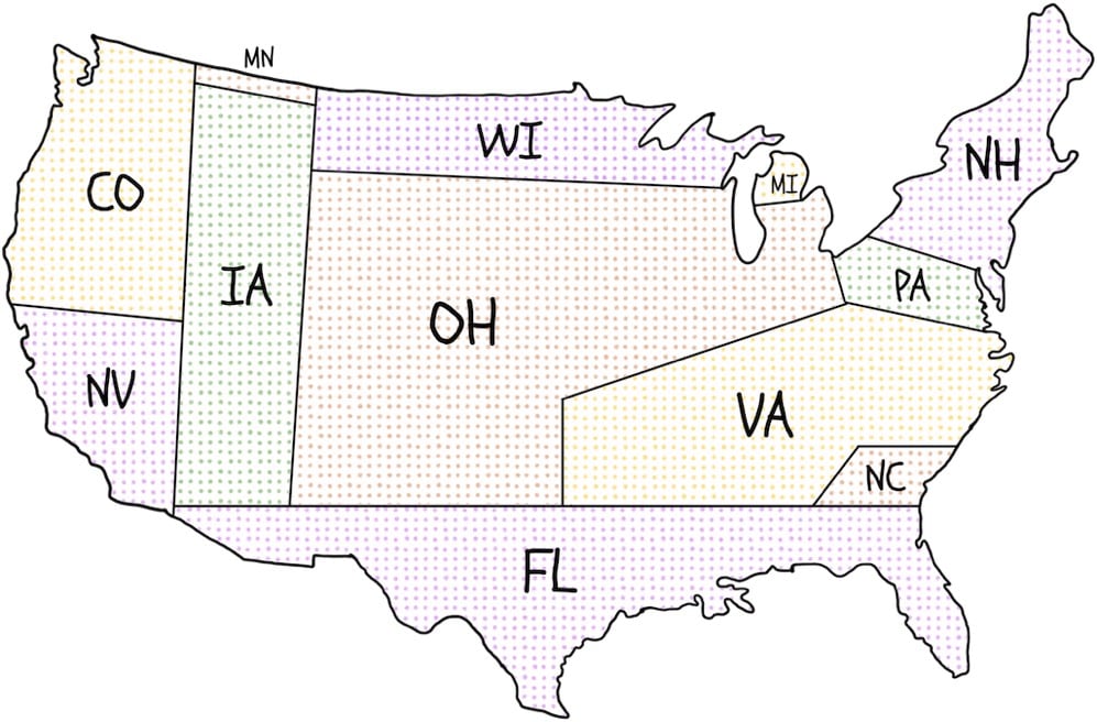
State winner-take-all statutes adversely affect governance. “Battleground” states receive 7% more federal grants than “spectator” states, twice as many presidential disaster declarations, more Superfund enforcement exemptions, and more No Child Left Behind law exemptions.
Also, because of state winner-take-all statutes, five of our 45 Presidents have come into office without having won the most popular votes nationwide. The 2000 and 2016 elections are the most recent examples of elections in which a second-place candidate won the White House. Near-misses are also common under the current state-by-state winner-take-all method of awarding electoral votes. A shift of 59,393 votes in Ohio in 2004 would have elected John Kerry despite President Bush’s nationwide lead of over 3,000,000 votes.
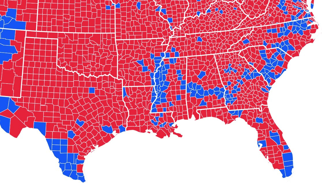
That’s a portion of the 2012 US Presidential election map of the southern states broken down by county: blue ones went Barack Obama’s way and counties in red voted for Mitt Romney.
But let’s go back to the Cretaceous Period, which lasted from 145 million years ago to 65 million years ago. Back then, the coastline of what is now North America looked like this:
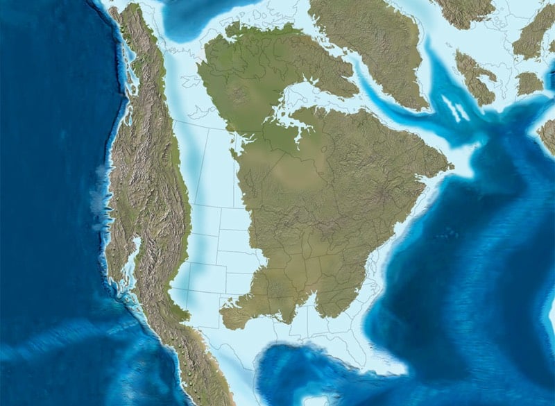
Along that ancient coastline of a shallow sea, plankton with carbonate skeletons lived and died in massive numbers, accumulating into large chalk formations on the bottom of the sea. When the sea level dropped and the sea drained through the porous chalk, rich bands of soil were left right along the former coastline. When that area was settled and farmed in the 19th century, that rich soil was perfect for growing cotton. And cotton production was particularly profitable, so enslaved people were heavily used in those areas.
McClain, quoting from Booker T. Washington’s autobiography, Up From Slavery, points out: “The part of the country possessing this thick, dark and naturally rich soil was, of course, the part of the South where the slaves were most profitable, and consequently they were taken there in the largest numbers.” After the Civil War, a lot of former slaves stayed on this land, and while many migrated North, their families are still there.
The counties in which slave populations were highest before the Civil War are still home to large African American populations, which tend to vote for Democratic presidential candidates, even as the whiter counties around them vote for Republicans. The voting pattern of those counties on the map follows the Cretaceous coastline of 100 million years ago — the plankton fell, the cotton grew, the enslaved people bled into that rich soil, and their descendants later helped a black man reach the White House.
It’s been a tough few weeks here in NYC. Sandy. Power outages. Food and gas shortages. The hurricane aftermath. Those two kids murdered by their nanny. The NYPD officer who was planning to kill and cook women. The election has been weighing heavily on my heart, more heavily than I realized. The Presidential campaign has been difficult for me to follow…so little substance and so so so much sound and fury, signifying nothing.
I’ve been pretty apathetic about politics in the past and I’ll never be the type of person to proselytize for one candidate over another (well, not too much anyway) but I would have waited in line for 12 hours today in order to cast my vote. Voting this morning1 felt like the first hopeful thing that’s happened in quite awhile.
[1] For Obama/Biden, I don’t mind telling you, not least because of the Republican Party’s contempt for the rights of the majority of the population, aka our wives, daughters, mothers, grandmothers, aunts, etc. ↩
Writing on his Tumblr blog (!!), former Secretary of Labor Robert Reich makes the case for a Clinton/Biden swap that would lead to an unstoppable Obama/Clinton presidental ticket in 2012.
My political prediction for 2012 (based on absolutely no inside information): Hillary Clinton and Joe Biden swap places. Biden becomes Secretary of State - a position he’s apparently coveted for years. And Hillary Clinton, Vice President.
So the Democratic ticket for 2012 is Obama-Clinton.
Why do I say this? Because Obama needs to stir the passions and enthusiasms of a Democratic base that’s been disillusioned with his cave-ins to regressive Republicans. Hillary Clinton on the ticket can do that.
(via ★djacobs)





Stay Connected