80 maps that explain the world
From the Washington Post, an interesting collection of 80 maps (in two parts: one and two) that explain the world and how it works. One of my favorites is this map of actual European discoveries of land previously unknown by humans.
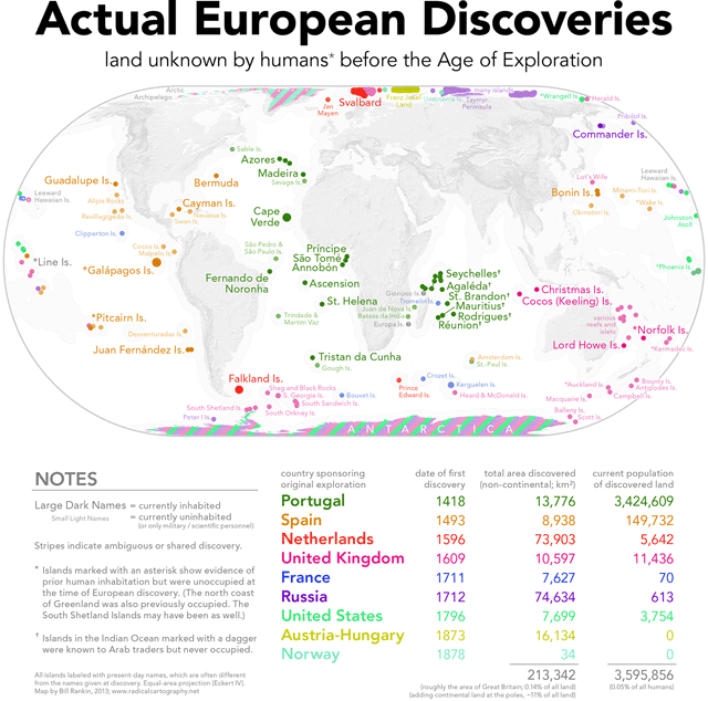
Antarctica is all stripey on that map and I realized I didn’t know who had first clapped their peepers on the only continent discovered in the last millennia, so I did some reading on the subject. From the Holy Book of Wikipedia:
The first land south of the parallel 60° south latitude was discovered by the Englishman William Smith, who sighted Livingston Island on 19 February 1819. A few months later Smith returned to explore the other islands of the South Shetlands archipelago, landed on King George Island, and claimed the new territories for Britain.
In the meantime, the Spanish Navy ship San Telmo sank in September 1819 when trying to cross Cape Horn. Parts of her wreckage were found months later by sealers on the north coast of Livingston Island (South Shetlands). It is unknown if some survivor managed to be the first setting foot on these Antarctic islands.
The first confirmed sighting of mainland Antarctica cannot be accurately attributed to one single person. It can, however, be narrowed down to three individuals. According to various sources, three men all sighted the ice shelf or the continent within days or months of each other: von Bellingshausen, a captain in the Russian Imperial Navy; Edward Bransfield, a captain in the British navy; and Nathaniel Palmer, an American sealer out of Stonington, Connecticut. It is certain that the expedition, led by von Bellingshausen and Lazarev on the ships Vostok and Mirny, reached a point within 32 km (20 mi) from Princess Martha Coast and recorded the sight of an ice shelf at 69°21′28″S 2°14′50″W that became known as the Fimbul ice shelf. On 30 January 1820, Bransfield sighted Trinity Peninsula, the northernmost point of the Antarctic mainland, while Palmer sighted the mainland in the area south of Trinity Peninsula in November 1820. Von Bellingshausen’s expedition also discovered Peter I Island and Alexander I Island, the first islands to be discovered south of the circle.
(via @daveg)
Socials & More