Why Weather Forecasts Have Gotten So Good
You may not have noticed, but weather forecasts — temperature, precipitation, hurricane tracks — have improved greatly over the past few decades.
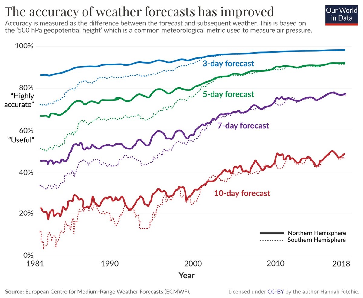
Dr. Hannah Ritchie of Our World in Data explains why.
The first big change is that the data has improved. More extensive and higher-resolution observations can be used as inputs into the weather models. This is because we have more and better satellite data, and because land-based stations are covering many more areas around the globe, and at a higher density. The precision of these instruments has improved, too.
These observations are then fed into numerical prediction models to forecast the weather. That brings us to the next two developments. The computers on which these models are run have gotten much faster. Faster speeds are crucial: the Met Office now chunks the world into grids of smaller and smaller squares. While they once modeled the world in 90-kilometer-wide squares, they are now down to a grid of 1.5-kilometer squares. That means many more calculations need to be run to get this high-resolution map. The methods to turn the observations into model outputs have also improved. We’ve gone from very simple visions of the world to methods that can capture the complexity of these systems in detail.
The final crucial factor is how these forecasts are communicated. Not long ago, you could only get daily updates in the daily newspaper. With the rise of radio and TV, you could get a few notices per day. Now, we can get minute-by-minute updates online or on our smartphones.
If you’re in the US, you can see how accurate the weather forecast is in your area by using ForecastAdvisor.
Comments 12
thread
latest
popular
Related book that isn't super-technical, "The Weather Machine" by Andrew Blum (link to Library of Congress listing, I tend not to post Amazon links if I can, but the book is available on Amazon for sure).
While I myself love reading the super-technical stuff about weather forecasting models, and have contemplated downloading the source code which is available from NOAA, I thought the book was a good general history of forecasting and forecasting models.
My research area! Ritchie cites a paper I wrote with Manuel Linsenmeier which shows that although forecasts have gotten better all around the world, there is a large gap in forecast quality between high and low income countries. 1-week-ahead forecasts in high-income countries are typically as accurate as 1-day-ahead forecasts in low-income countries. And this gap has remained relatively unchanged for the last few decades.
Looking at the charts I was curious if the low/high income gap might be exacerbated by the Northern/Southern Hemisphere gap? With less land mass, there would be fewer land-based stations in the Southern Hemisphere, making predictions harder. Combine that with less money to spend on weather planes and satellites and a tropical storm coming in from the wide-open Pacific to a country like the Philippines or Indonesia would be harder to predict than a hurricane heading to Florida.
I think there is also a gap in marine weather forecasts vs land forecasts. As a boater, I feel subjectively that the forecasts are less accurate this year than 3-4 years ago. Maybe it is just that I have access to more models now, and the models don't agree with each other like I want them to!
Thanks for checking out the paper, folks! Martin, the Northern/Southern Hemisphere gap could be playing a role. There has been really good progress in closing the gap in forecast quality between the whole extratropical Northern and Southern Hemispheres, as the posted figure from Our World in Data shows. But that includes a lot of ocean, so your point about lower land mass--and therefore fewer stations--is something we should look into. In our analysis, we emphasize that a lot of the gap between high and low-income countries comes from the tropics being hard to forecast. The tropics have much less weather observing infrastructure. Tropical weather forecasting is also just more challenging due to the physics of weather systems in the region.
Louise, we restrict our analysis to land, so I don't know what's been happening with marine forecasts. Your "access to models" explanation sounds like the start of a good research question!
I had no idea ForecastAdvisor was a thing. I'd been thinking about how we might gauge the accuracy of weather forecasts and here we are, someone built it. Fantastic!
Ok, I agree with this, but then WHY DOES THE APPLE WEATHER APP SUCK???
It is a bit of a mystery! Vox published a piece where the reporter talked to lots of meteorologists about it, but no firm conclusions were reached. The explanation that makes most sense to me--though it is hard to admit--is that maybe Dark Sky was never that accurate to begin with. ForecastAdvisor, which Jason linked to, tracked the accuracy of Dark Sky before it was shut down, and it didn't fare too well (reporting here).
I have been so interested in how to measure the accuracy of weather predictions! When there is a 70% chance of rain and it doesn't rain, you hear people grumbling about forecasters. It hurts my brain to think about how to evaluate data to define the properties of that random variable. Love that Dr. Schrader got to see his paper referenced -- this community rules.
Once upon a time (32 years ago!) I visited ECMWF - the European Centre for Medium-Range Weather Forecasting. I was doing a week's work experience with Cray Research (*humblebrag*) and ECMWF always had the latest and greatest of Cray's machines.
As noted in the article, the grid density has been getting higher (i.e. smaller squares) as the computers running the models have increased in speed. I think ECMWF wanted to generate a 10-day forecast in 90 minutes - the grid size was selected to hit the simulation runtime.
Ended up back here from the meta-comment discussion and wanted to chime in with this: as someone who a. went to school in Miami, FL and took classes on hurricanes/meteorology, b. participates in a couple of highly weather dependent sports (surfing/snowboarding), I have a DEEP appreciation for local meteorologist blogs. The best of which is this one, about my home ski region.
If you feel like this comment goes against the grain of the community guidelines or is otherwise inappropriate, please let me know and I will take a look at it.
This thread is closed for new comments & replies. Thanks to everyone for participating!