Historical maps on Google Earth
Google Earth recently added some maps from the David Rumsey Historical Map Collection to their software, so you can just click them on and off on the globe. Included are a US map from 1833, a 1680 map of Tokyo, Paris from 1716, and a world map from 1790. I spent some time exploring the map of New York from 1836. Here’s a screenshot of the southern tip of Manhattan with the present-day buildings turned on:
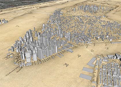
A larger version is available on Flickr. Google Earth continues to be a fantastic software product. It’s almost more of a game than an atlas or educational program…so much fun.
Related: I did a project using Google Earth called Manhattan Elsewhere and made a scrollable, zoomable version of Viele’s Map of Manhattan.
Socials & More