Manhattan Elsewhere
A few months ago, I found a map online (which I cannot for the life of me relocate and I’m keen to find it again…any ideas? it’s from Bill Rankin’s The Errant Isle of Manhattan…see update below) of Manhattan pasted next to Chicago, as if the island had taken up permanent residence in Lake Michigan. Recently I decided to explore the unique aspect of Manhattan’s scale with a series of similar maps of places I’ve been to or lived in: Boston, Chicago, Minneapolis, San Francisco, and Barron, WI (my hometown). Manhattan Elsewhere is the result.
Depending on your vantage point, Manhattan seems either very big or very small. On complete map of the New York City area, Manhattan is dwarfed in size by the other four boroughs and surrounding megopolis. But for someone on the ground in Manhattan, the population density, the height of the buildings, the endless number of things to do, and the fact that many people don’t often leave their neighborhoods, much less the island, for weeks/months on end makes it seem a very large place indeed. This divergence sense of scales can cause quite a bit of cognitive dissonance for residents and visitors alike.
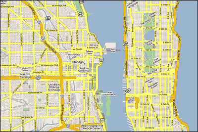
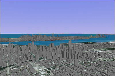
For the top image, I used the Google Maps representations of Manhattan and Chicago to create a composite map. In the bottom image, I used Google Earth’s 3-D views to create a approximate view of Manhattan from Chicago. In all cases, Manhattan is to scale with the other cities. Click through for larger images and other cities.
Update: The map on which Manhattan Elsewhere is based was done by Bill Rankin, who runs the excellent Radical Cartography site, and is part of The Errant Isle of Manhattan project. He also did maps for Boston, SF, Door County, WI, Philly, and Los Angeles (look at how gigantic LA is!), which I completely forgot about. He also made more of an effort than I did to connect the roads. (thx, zach)
Stay Connected