Satellite imagery used to spot human rights abuses
The American Association for the Advancement of Science (AAAS) is exploring the use of satellite imagery to detect and prove human rights abuses. It’s difficult to deny the communication potential of these images:
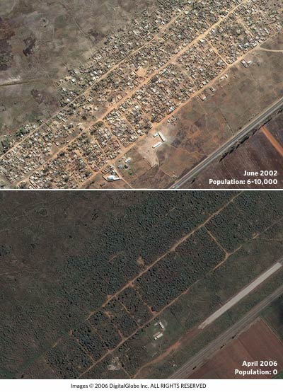
Larger versions of the images are available (before and after).
The images, analyzed by the AAAS staff, show two views of the settlement of Porta Farm, located just west of the Zimbabwean capital of Harare. The first, an archived image from June 2002, shows an intact settlement with more than 850 homes and other buildings; an estimated 6,000 to 10,000 people lived in Porta Farm at the time. The second photo, taken by satellite on 6 April this year, shows that the settlement has been leveled.
International rights groups allege that the forced relocations in Zimbabwe — which affected over 700,000 people over the course of six weeks in 2005 — are an attempt by the Mugabe government to supress opposition to the current regime.
The AAAS and other organizations hope to use satellite imagery in the future as a tool in addressing the human rights abuses in Darfur, Burma, and other areas. (via rw)

Socials & More